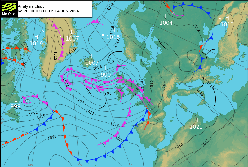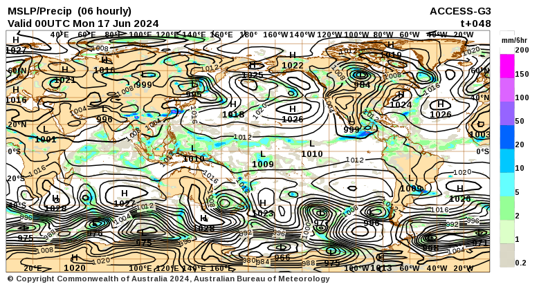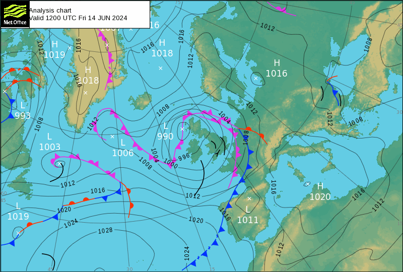
Problem with Vivaldi is the data was not presented. I never thought to hit: “Control-“.
Life
Life oh, life… Oh.. what does it mean
Life oh, life… Well,
Oh, what does it mean
Australian citizen free from prison after
Oh.. what does that mean?
Five.. five years behind bars means ten in the UK
Apart plea deal with the US Justice.
Oh.. What does that mean?
Seven year home of Journalist Julian Assange
Alone at London’s Stansted Airport
That’s twelve older but still alive
Serving like Peter where he did not want to go
Life, oh life.. Northern Mariana Islands
Guilty of Espionage Oh.. in USA
I wonder how long he’s got before the lunatics get him but for now, I’d like to know how much the Columbia Embassy held out for. Oh.. Oh.. Oh.. oh.
SCOTUS ruled that juries must unanimously agree on determining what crimes were committed before issuing a verdict.
I don’t believe the British want them back, Maybe after Trump has had a second go at them. They must get rid of the liberals first though.
As for the rest I found the lost data, no thanks to Vivaldi. Mostly my fault but I had to find another website before I realised what I had done. At least it gave me a chance to think about reintroducing another go around.
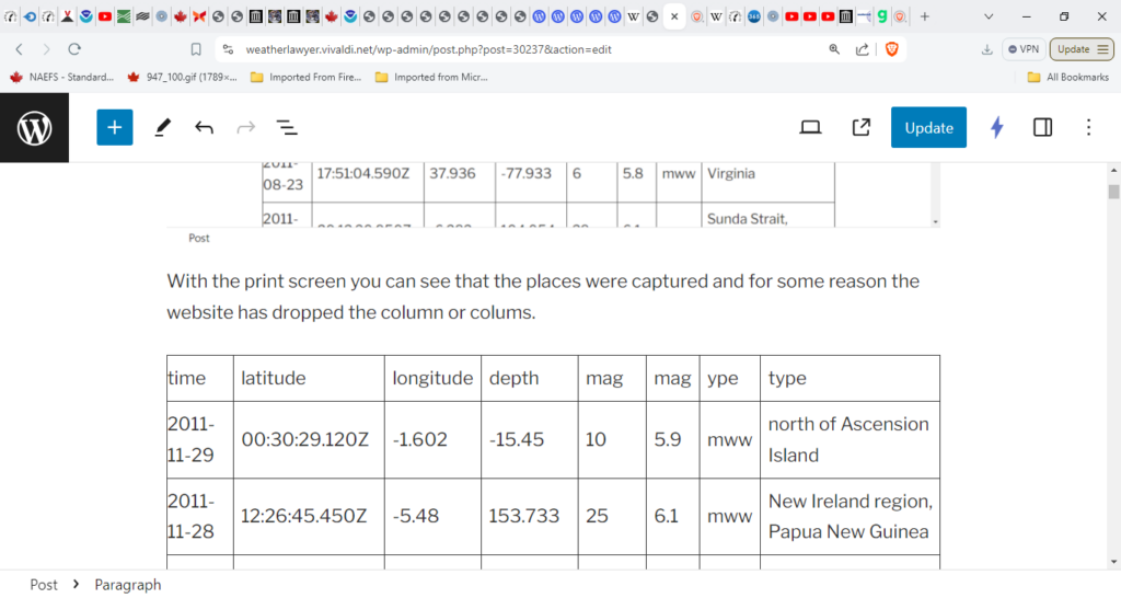
With the print screen you can see that the places were captured and for some reason the website has dropped the column or colums.
| time | latitude | longitude | depth | mag | mag | ype | type |
| 2011-11-29 | 00:30:29.120Z | -1.602 | -15.45 | 10 | 5.9 | mww | north of Ascension Island |
| 2011-11-28 | 12:26:45.450Z | -5.48 | 153.733 | 25 | 6.1 | mww | New Ireland region, Papua New Guinea |
| 2011-11-28 | 09:13:11.340Z | -7.019 | 116.983 | 616.5 | 5.8 | mww | Bali Sea |
| 2011-11-24 | 10:25:34.030Z | 41.898 | 142.639 | 38 | 6.2 | mww | Hokkaido, Japan region |
| 2011-11-23 | 19:24:31.470Z | 37.365 | 141.368 | 34 | 6.1 | mww | near the east coast of Honshu, Japan |
| 2011-11-23 | 12:17:51.280Z | 34.285 | 25.083 | 10 | 5.5 | mwc | Crete, Greece |
| 2011-11-22 | 18:48:16.300Z | -15.364 | -65.09 | 549.9 | 6.6 | mww | Beni, Bolivia |
| 2011-11-21 | 03:15:41.560Z | 24.96 | 95.232 | 107 | 5.7 | mww | Myanmar |
| 2011-11-20 | 16:31:38.710Z | -2.952 | 142.138 | 10 | 5.7 | mwb | near the north coast of New Guinea, Papua New Guinea |
| 2011-11-19 | 18:06:24.300Z | 53.134 | -174.135 | 214.9 | 5.5 | mww | Andreanof Islands, Aleutian Islands, Alaska |
| 2011-11-18 | 07:51:24.660Z | -37.806 | 179.418 | 12 | 5.8 | mww | off the east coast of the North Island of New Zealand |
| 2011-11-18 | 06:00:53.970Z | 33.704 | -38.495 | 10 | 5.7 | mwc | northern Mid-Atlantic Ridge |
| 2011-11-18 | 04:34:03.020Z | -37.423 | 179.989 | 33 | 5.6 | mww | off the east coast of the North Island of New Zealand |
| 2011-11-17 | 13:30:58.910Z | 13.973 | -91.718 | 34 | 5.8 | mww | offshore Guatemala |
| 2011-11-17 | 06:52:41.330Z | 8.415 | -103.158 | 10 | 5.6 | mwc | northern East Pacific Rise |
| 2011-11-17 | 01:57:05.730Z | -1.702 | -81.546 | 26.6 | 6 | mww | off the coast of Ecuador |
| 2011-11-15 | 23:42:29.290Z | -5.28 | 140.311 | 12 | 5.7 | mww | Papua, Indonesia |
| 2011-11-15 | 10:43:51.850Z | -0.095 | 121.914 | 276.2 | 5.7 | mww | Sulawesi, Indonesia |
| 2011-11-15 | 07:56:02.230Z | -7.482 | 127.849 | 166 | 5.5 | mww | Kepulauan Barat Daya, Indonesia |
| 2011-11-14 | 04:05:11.390Z | -0.949 | 126.91 | 17 | 6.3 | mww | Molucca Sea |
| 2011-11-11 | 22:50:40.740Z | -55.707 | -124.327 | 10 | 5.6 | mwc | southern East Pacific Rise |
| 2011-11-11 | 15:02:19.930Z | -17.708 | -173.095 | 10 | 5.6 | mwb | Tonga |
| 2011-11-11 | 10:41:37.480Z | -55.981 | -124.439 | 10 | 6 | mww | southern East Pacific Rise |
| 2011-11-09 | 21:52:20.480Z | 10.542 | 146.095 | 10.5 | 5.7 | mww | south of the Mariana Islands |
| 2011-11-09 | 19:23:33.240Z | 38.429 | 43.229 | 5 | 5.6 | mww | eastern Turkey |
| 2011-11-08 | 02:59:08.510Z | 27.324 | 125.621 | 224.9 | 6.9 | mww | northeast of Taiwan |
| 2011-11-07 | 22:35:25.630Z | 11.56 | -85.861 | 177 | 6 | mww | Nicaragua |
| 2011-11-07 | 16:51:25.100Z | -63.245 | 170.735 | 5.5 | 5.8 | mww | Balleny Islands region |
| 2011-11-07 | 11:59:31.440Z | 36.502 | 71.102 | 212.1 | 5.6 | mwb | Hindu Kush region, Afghanistan |
| 2011-11-06 | 08:08:13.270Z | 54.12 | -162.549 | 23.2 | 5.7 | mww | Alaska Peninsula |
| 2011-11-06 | 03:53:10.000Z | 35.532 | -96.765 | 5.2 | 5.6 | mww | Oklahoma |
| 2011-11-05 | 07:13:57.990Z | -23.468 | -70.199 | 33 | 5.7 | mww | Antofagasta, Chile |
| 2011-11-05 | 01:49:18.830Z | -18.241 | 168.304 | 34 | 5.9 | mww | Vanuatu |
| 2011-11-04 | 15:43:43.320Z | -15.094 | 167.384 | 134.1 | 5.8 | mww | Vanuatu |
| 2011-11-02 | 14:59:27.940Z | -55.294 | -128.843 | 10 | 6.1 | mww | Pacific-Antarctic Ridge |
| 2011-11-01 | 12:32:00.430Z | 19.831 | -109.205 | 10 | 6.3 | mww | Revilla Gigedo Islands region |
| 2011-11-01 | 00:21:28.090Z | 43.648 | 82.437 | 28 | 5.6 | mww | northern Xinjiang, China |
| 2011-10-31 | 07:16:21.610Z | 52.366 | 177.932 | 159 | 5.8 | mww | Rat Islands, Aleutian Islands, Alaska |
| 2011-10-31 | 04:45:43.830Z | -23.346 | -114.963 | 10 | 5.5 | mwc | Easter Island region |
| 2011-10-30 | 18:53:43.000Z | -25.741 | -70.959 | 47.1 | 5.7 | mwb | near the coast of Antofagasta, Chile |
| 2011-10-30 | 11:52:27.420Z | -3.249 | 101.345 | 36 | 5.6 | mwb | southern Sumatra, Indonesia |
| 2011-10-30 | 03:23:46.000Z | 25.372 | 122.866 | 224.2 | 5.7 | mwb | Taiwan region |
| 2011-10-28 | 23:46:01.720Z | -14.512 | -75.844 | 10 | 5.6 | mwc | near the coast of central Peru |
| 2011-10-28 | 19:01:02.330Z | -14.379 | -75.998 | 22.3 | 5.6 | mb | near the coast of central Peru |
| 2011-10-28 | 18:54:34.040Z | -14.438 | -75.966 | 24 | 6.9 | mww | near the coast of central Peru |
| 2011-10-27 | 00:15:24.520Z | -17.941 | -179.531 | 602.9 | 6 | mww | Fiji region |
| 2011-10-25 | 14:55:08.240Z | 38.811 | 43.623 | 14 | 5.6 | mww | eastern Turkey |
| 2011-10-25 | 03:24:49.630Z | 52.159 | -171.826 | 38 | 5.7 | mww | Fox Islands, Aleutian Islands, Alaska |
| 2011-10-23 | 20:45:34.860Z | 38.634 | 43.077 | 5 | 5.9 | mww | eastern Turkey |
| 2011-10-23 | 11:32:41.220Z | 38.809 | 43.3 | 5 | 5.7 | mb | eastern Turkey |
| 2011-10-23 | 10:56:49.000Z | 38.814 | 43.446 | 5 | 5.6 | mb | eastern Turkey |
| 2011-10-23 | 10:48:17.420Z | 38.751 | 43.595 | 9 | 5.6 | mb | eastern Turkey |
| 2011-10-23 | 10:41:23.250Z | 38.721 | 43.508 | 18 | 7.1 | mww | eastern Turkey |
| 2011-10-21 | 17:57:16.100Z | -28.993 | -176.238 | 33 | 7.4 | mww | Kermadec Islands region |
| 2011-10-21 | 08:02:37.950Z | 43.892 | 142.479 | 187 | 6.1 | mww | Hokkaido, Japan region |
| 2011-10-18 | 05:05:06.250Z | -5.785 | 151.037 | 26 | 6.1 | mww | New Britain region, Papua New Guinea |
| 2011-10-15 | 22:24:49.330Z | -25.788 | -177.455 | 147.7 | 5.5 | mwc | south of the Fiji Islands |
| 2011-10-14 | 06:10:14.600Z | 54.08 | 123.722 | 12 | 6 | mww | Amurskaya Oblast’, Russia |
| 2011-10-14 | 03:35:14.810Z | -6.57 | 147.881 | 37 | 6.5 | mww | eastern New Guinea region, Papua New Guinea |
| 2011-10-13 | 04:14:00.510Z | 43.462 | -127.135 | 20.6 | 5.6 | mwc | off the coast of Oregon |
| 2011-10-13 | 03:16:30.160Z | -9.35 | 114.587 | 39 | 6.1 | mww | south of Bali, Indonesia |
| 2011-10-11 | 13:05:49.030Z | -2.247 | 138.838 | 27.2 | 5.7 | mww | Papua, Indonesia |
| 2011-10-10 | 05:18:10.560Z | -25.459 | -116.219 | 10 | 5.5 | mwc | southern East Pacific Rise |
| 2011-10-10 | 02:45:57.860Z | 37.547 | 141.257 | 46 | 5.6 | mww | near the east coast of Honshu, Japan |
| 2011-10-09 | 18:01:47.820Z | -50.076 | -115.958 | 10 | 5.5 | mwc | southern East Pacific Rise |
| 2011-10-08 | 08:53:11.960Z | -20.602 | -173.222 | 6 | 5.9 | mww | Tonga |
| 2011-10-08 | 05:38:54.980Z | -4.694 | 134.137 | 10.1 | 5.7 | mww | near the south coast of Papua, Indonesia |
| 2011-10-07 | 08:58:28.910Z | -32.514 | -179.038 | 36 | 6.1 | mww | south of the Kermadec Islands |
| 2011-10-07 | 06:30:19.620Z | -22.212 | 171.222 | 118.6 | 5.6 | mwc | southeast of the Loyalty Islands |
| 2011-10-06 | 11:12:30.070Z | -24.178 | -64.219 | 15 | 5.9 | mww | Jujuy, Argentina |
| 2011-10-06 | 07:37:01.420Z | 9.7 | 138.245 | 20 | 5.8 | mww | State of Yap, Federated States of Micronesia |
| 2011-10-06 | 00:39:32.850Z | 57.89 | -32.492 | 10 | 5.5 | mww | Reykjanes Ridge |
| 2011-10-04 | 01:37:29.130Z | 26.768 | 140.429 | 455.9 | 5.6 | mww | Bonin Islands, Japan region |
| 2011-10-01 | 10:54:29.760Z | -48.978 | 164.542 | 10 | 5.6 | mwb | off the west coast of the South Island of New Zealand |
| 2011-09-28 | 22:40:12.860Z | -37.952 | -73.853 | 10 | 5.6 | mwb | offshore Bio-Bio, Chile |
| 2011-09-23 | 19:02:48.240Z | -9.051 | -109.44 | 10 | 5.9 | mww | central East Pacific Rise |
| 2011-09-22 | 23:07:03.570Z | -15.437 | -175.311 | 10 | 6.4 | mww | Tonga |
| 2011-09-22 | 03:22:36.070Z | 39.785 | 38.842 | 5 | 5.5 | mwb | eastern Turkey |
| 2011-09-20 | 02:40:22.690Z | -4.532 | -105.207 | 10 | 5.7 | mwc | central East Pacific Rise |
| 2011-09-19 | 18:33:55.870Z | 14.186 | -90.238 | 9 | 5.6 | mwr | Guatemala |
| 2011-09-19 | 08:14:14.760Z | 52.037 | -171.982 | 31 | 5.6 | mww | Fox Islands, Aleutian Islands, Alaska |
| 2011-09-18 | 12:40:51.830Z | 27.73 | 88.155 | 50 | 6.9 | mww | Sikkim, India |
| 2011-09-18 | 07:04:18.070Z | 39.845 | 143.052 | 10 | 5.6 | mww | off the east coast of Honshu, Japan |
| 2011-09-17 | 07:34:27.690Z | 40.265 | 142.657 | 30 | 5.7 | mwc | near the east coast of Honshu, Japan |
| 2011-09-16 | 22:40:46.930Z | 40.242 | 143.145 | 37.7 | 5.7 | mwc | off the east coast of Honshu, Japan |
| 2011-09-16 | 21:36:38.590Z | 40.077 | 143.15 | 40.7 | 5.8 | mwc | off the east coast of Honshu, Japan |
| 2011-09-16 | 21:08:05.330Z | 40.239 | 143.008 | 18 | 5.9 | mww | off the east coast of Honshu, Japan |
| 2011-09-16 | 20:11:16.090Z | 40.235 | 143.24 | 35 | 5.7 | mwc | off the east coast of Honshu, Japan |
| 2011-09-16 | 19:26:40.260Z | 40.273 | 142.779 | 30 | 6.7 | mwc | near the east coast of Honshu, Japan |
| 2011-09-16 | 18:23:24.740Z | -20.679 | 169.79 | 106.4 | 5.5 | mww | Vanuatu |
| 2011-09-15 | 19:31:04.080Z | -21.611 | -179.528 | 644.6 | 7.3 | mww | Fiji region |
| 2011-09-15 | 11:59:52.770Z | -14.956 | -177.957 | 378.4 | 5.5 | mww | Fiji region |
| 2011-09-15 | 08:00:09.640Z | 36.256 | 141.338 | 28 | 6.1 | mww | near the east coast of Honshu, Japan |
| 2011-09-15 | 07:53:18.630Z | -35.366 | -179.039 | 10 | 6.1 | mww | east of the North Island of New Zealand |
| 2011-09-14 | 18:10:09.000Z | 53.107 | 172.984 | 15 | 6 | mww | Near Islands, Aleutian Islands, Alaska |
| 2011-09-14 | 13:36:34.120Z | -35.111 | -178.991 | 13 | 5.7 | mwc | east of the North Island of New Zealand |
| 2011-09-14 | 07:03:51.000Z | -32.696 | -71.797 | 37 | 5.8 | mww | offshore Valparaiso, Chile |
| 2011-09-13 | 04:49:35.000Z | 5.617 | -77.471 | 10 | 5.7 | mwb | near the west coast of Colombia |
| 2011-09-12 | 22:44:28.080Z | -3.626 | 144.178 | 14 | 5.9 | mww | near the north coast of New Guinea, Papua New Guinea |
| 2011-09-11 | 23:37:34.890Z | -18.188 | 167.734 | 29 | 5.8 | mww | Vanuatu |
| 2011-09-09 | 19:41:34.150Z | 49.535 | -126.893 | 22 | 6.4 | mww | Vancouver Island, Canada region |
| 2011-09-09 | 19:26:01.040Z | -49.586 | 164.007 | 10 | 5.9 | mww | Auckland Islands, New Zealand region |
| 2011-09-07 | 07:55:32.660Z | -27.771 | -178.461 | 252.1 | 5.5 | mwc | Kermadec Islands region |
| 2011-09-05 | 17:55:11.220Z | 2.965 | 97.893 | 91 | 6.7 | mww | northern Sumatra, Indonesia |
| 2011-09-05 | 11:21:36.940Z | 6.564 | -82.358 | 24.7 | 5.8 | mww | south of Panama |
| 2011-09-05 | 09:52:01.130Z | -15.295 | -173.621 | 37 | 6.2 | mww | Tonga |
| 2011-09-04 | 21:44:18.060Z | -19.18 | 168.705 | 37 | 5.8 | mww | Vanuatu |
| 2011-09-03 | 22:55:40.920Z | -20.671 | 169.716 | 185.1 | 7 | mww | Vanuatu |
| 2011-09-03 | 16:20:41.000Z | -38.435 | -74.907 | 12 | 5.8 | mww | off the coast of Araucania, Chile |
| 2011-09-03 | 04:48:57.310Z | -56.451 | -26.847 | 84 | 6.4 | mww | South Sandwich Islands region |
| 2011-09-03 | 01:06:53.780Z | -12.781 | 166.79 | 85 | 5.8 | mww | Santa Cruz Islands |
| 2011-09-02 | 13:47:09.620Z | -28.398 | -63.029 | 578.9 | 6.7 | mww | Santiago Del Estero, Argentina |
| 2011-09-02 | 10:55:53.590Z | 52.171 | -171.708 | 32 | 6.9 | mww | Fox Islands, Aleutian Islands, Alaska |
| 2011-09-01 | 06:14:38.870Z | -12.36 | 166.656 | 41 | 6 | mww | Santa Cruz Islands |
| 2011-08-31 | 12:17:27.010Z | 43.589 | -28.902 | 10 | 5.5 | mww | northern Mid-Atlantic Ridge |
| 2011-08-31 | 10:46:49.470Z | -5.907 | 153.278 | 35.9 | 5.6 | mww | New Ireland region, Papua New Guinea |
| 2011-08-30 | 06:57:41.610Z | -6.362 | 126.752 | 469.8 | 6.9 | mww | Banda Sea |
| 2011-08-29 | 18:57:39.010Z | -16.35 | 167.941 | 202.3 | 5.6 | mwc | Vanuatu |
| 2011-08-28 | 10:10:19.490Z | -24.535 | -115.945 | 10 | 5.6 | mwc | southern East Pacific Rise |
| 2011-08-27 | 20:31:53.300Z | -24.593 | 179.924 | 508.7 | 5.7 | mwc | south of the Fiji Islands |
| 2011-08-25 | 14:23:45.220Z | -18.275 | 167.615 | 35 | 5.5 | mwc | Vanuatu |
| 2011-08-25 | 10:39:58.190Z | -13.598 | 166.996 | 158.6 | 5.9 | mww | Vanuatu |
| 2011-08-24 | 23:06:17.090Z | -18.155 | 167.727 | 13 | 6.2 | mww | Vanuatu |
| 2011-08-24 | 17:46:11.650Z | -7.641 | -74.525 | 147 | 7 | mww | northern Peru |
| 2011-08-23 | 17:51:04.590Z | 37.936 | -77.933 | 6 | 5.8 | mww | Virginia |
| 2011-08-22 | 20:12:20.950Z | -6.282 | 104.054 | 29 | 6.1 | mww | Sunda Strait, Indonesia |
| 2011-08-22 | 11:23:35.250Z | 36.083 | 141.688 | 12 | 5.9 | mww | near the east coast of Honshu, Japan |
| 2011-08-22 | 09:38:37.310Z | -29.026 | -176.676 | 10 | 5.7 | mwc | Kermadec Islands region |
| 2011-08-22 | 06:04:53.880Z | -17.428 | 167.268 | 10 | 5.7 | mww | Vanuatu |
| 2011-08-21 | 13:04:08.160Z | -5.57 | 151.024 | 40 | 5.8 | mww | New Britain region, Papua New Guinea |
| 2011-08-21 | 12:38:53.780Z | -56.428 | -27.494 | 130.4 | 5.6 | mwc | South Sandwich Islands region |
| 2011-08-21 | 02:09:15.820Z | -18.6 | 168.165 | 35.2 | 5.5 | mwc | Vanuatu |
| 2011-08-21 | 00:23:39.650Z | -18.24 | 167.867 | 35 | 5.6 | mwb | Vanuatu |
| 2011-08-20 | 18:19:23.550Z | -18.311 | 168.218 | 28 | 7.1 | mww | Vanuatu |
| 2011-08-20 | 17:13:06.380Z | -18.308 | 168.156 | 35 | 6.5 | mwc | Vanuatu |
| 2011-08-20 | 16:55:02.810Z | -18.365 | 168.143 | 32 | 7.2 | mww | Vanuatu |
| 2011-08-20 | 10:27:17.320Z | -15.878 | -179.451 | 10 | 5.5 | mwc | Fiji region |
| 2011-08-20 | 01:24:59.960Z | -22.504 | -174.944 | 10 | 5.6 | mwc | Tonga region |
| 2011-08-19 | 05:36:33.040Z | 37.671 | 141.652 | 47 | 6.2 | mww | near the east coast of Honshu, Japan |
| 2011-08-19 | 03:54:26.780Z | -16.522 | -177.004 | 407.9 | 6.2 | mww | Fiji region |
| 2011-08-17 | 11:44:08.370Z | 36.765 | 143.77 | 9 | 6.1 | mww | off the east coast of Honshu, Japan |
| 2011-08-16 | 20:24:03.670Z | -57.229 | -25.452 | 44.3 | 5.7 | mww | South Sandwich Islands region |
| 2011-08-16 | 17:33:07.620Z | -5.557 | 147.144 | 186.4 | 5.6 | mwb | eastern New Guinea region, Papua New Guinea |
| 2011-08-16 | 11:03:56.430Z | -2.323 | 128.011 | 26 | 6.1 | mww | Ceram Sea, Indonesia |
| 2011-08-15 | 02:53:18.660Z | -1.814 | -76.908 | 177.2 | 5.7 | mww | Ecuador |
| 2011-08-14 | 01:29:39.340Z | -1.337 | -14.653 | 10 | 5.6 | mwb | north of Ascension Island |
| 2011-08-13 | 07:33:06.120Z | 14.394 | -94.674 | 6 | 5.8 | mww | off the coast of Chiapas, Mexico |
| 2011-08-13 | 07:14:47.590Z | -30.551 | -177.932 | 10 | 5.5 | mwc | Kermadec Islands, New Zealand |
| 2011-08-12 | 03:15:09.130Z | -21.805 | -177.021 | 218.8 | 5.5 | mww | Fiji region |
| 2011-08-11 | 18:22:04.920Z | 37.034 | 140.893 | 44 | 5.8 | mww | eastern Honshu, Japan |
| 2011-08-11 | 10:06:29.350Z | 39.955 | 77.028 | 10 | 5.6 | mww | southern Xinjiang, China |
| 2011-08-11 | 01:13:41.240Z | -24.799 | 179.919 | 496.8 | 5.7 | mwc | south of the Fiji Islands |
| 2011-08-10 | 23:45:43.040Z | -7.04 | -12.618 | 10 | 6 | mww | Ascension Island region |
| 2011-08-10 | 00:53:24.680Z | 27.723 | 65.082 | 37 | 5.7 | mww | Pakistan |
| 2011-08-08 | 23:53:23.150Z | -11.11 | 162.339 | 23.2 | 5.6 | mwc | Solomon Islands |
| 2011-08-07 | 06:22:34.420Z | -11.791 | 168.308 | 403.4 | 5.6 | mww | Santa Cruz Islands region |
| 2011-08-06 | 13:22:34.000Z | -35.884 | -73.334 | 31.9 | 5.5 | mwc | offshore Bio-Bio, Chile |
| 2011-08-05 | 16:08:45.580Z | -29.989 | -176.728 | 10 | 5.7 | mwc | Kermadec Islands region |
| 2011-08-04 | 13:51:34.560Z | 48.833 | 154.769 | 36 | 6.1 | mww | Kuril Islands |
| 2011-08-04 | 00:16:07.470Z | -2.837 | 101.09 | 35 | 5.8 | mww | southern Sumatra, Indonesia |
| 2011-08-03 | 22:39:23.010Z | -5.045 | 148.161 | 10 | 5.7 | mww | New Britain region, Papua New Guinea |
| 2011-08-02 | 19:18:46.840Z | -23.983 | 179.007 | 528.9 | 5.7 | mww | south of the Fiji Islands |
| 2011-08-01 | 18:20:05.030Z | 51.792 | -171.267 | 41.2 | 5.6 | mwc | Fox Islands, Aleutian Islands, Alaska |
| 2011-08-01 | 14:58:09.060Z | 34.631 | 138.433 | 13 | 5.9 | mww | near the south coast of Honshu, Japan |
| 2011-08-01 | 13:44:47.300Z | 39.837 | 142.083 | 40 | 5.7 | mww | near the east coast of Honshu, Japan |
| 2011-07-31 | 23:38:56.610Z | -3.518 | 144.828 | 10 | 6.6 | mww | near the north coast of New Guinea, Papua New Guinea |
| 2011-07-31 | 17:35:57.870Z | 41.795 | 142.826 | 32.4 | 5.5 | mb | Hokkaido, Japan region |
| 2011-07-31 | 14:34:47.320Z | -17.016 | 171.579 | 10 | 6.1 | mww | Vanuatu region |
| 2011-07-30 | 18:53:50.720Z | 36.942 | 140.955 | 38 | 6.3 | mww | near the east coast of Honshu, Japan |
| 2011-07-30 | 17:48:51.990Z | 12.899 | 143.234 | 122.4 | 5.5 | mww | Guam region |
| 2011-07-29 | 07:42:23.400Z | -23.801 | 179.751 | 532 | 6.7 | mww | south of the Fiji Islands |
| 2011-07-28 | 19:50:20.060Z | -35.77 | -73.116 | 35 | 5.7 | mww | offshore Maule, Chile |
| 2011-07-28 | 09:01:39.030Z | 40.344 | 143.236 | 30.9 | 5.6 | mww | off the east coast of Honshu, Japan |
| 2011-07-27 | 23:00:29.670Z | 10.799 | -43.391 | 6 | 5.9 | mww | northern Mid-Atlantic Ridge |
| 2011-07-26 | 17:44:20.380Z | 25.101 | -109.525 | 12 | 6 | mww | Gulf of California |
| 2011-07-26 | 14:26:22.870Z | -9.23 | 67.113 | 10 | 5.8 | mww | Mid-Indian Ridge |
| 2011-07-26 | 06:17:37.480Z | 52.99 | 159.794 | 33 | 5.6 | mww | off the east coast of the Kamchatka Peninsula, Russia |
| 2011-07-25 | 17:15:40.810Z | 14.947 | 120.043 | 35 | 5.9 | mww | Luzon, Philippines |
| 2011-07-25 | 11:54:54.080Z | 35.273 | 140.933 | 46 | 5.6 | mwc | near the east coast of Honshu, Japan |
| 2011-07-25 | 00:50:47.590Z | -3.182 | 150.611 | 10 | 6.3 | mww | New Ireland region, Papua New Guinea |
| 2011-07-24 | 18:51:25.070Z | 37.73 | 141.39 | 40 | 6.3 | mww | near the east coast of Honshu, Japan |
| 2011-07-23 | 16:34:41.820Z | 13.107 | 145.253 | 14 | 5.5 | mwb | Guam region |
| 2011-07-23 | 06:28:34.630Z | 54.695 | -161.148 | 22.8 | 5.7 | mwc | Alaska Peninsula |
| 2011-07-23 | 04:34:24.180Z | 38.898 | 141.815 | 41 | 6.3 | mww | near the east coast of Honshu, Japan |
| 2011-07-23 | 02:56:51.350Z | -29.335 | -69.705 | 103.4 | 5.5 | mwb | San Juan, Argentina |
| 2011-07-22 | 06:56:40.860Z | -20.325 | -178.595 | 612.1 | 5.9 | mww | Fiji region |
| 2011-07-21 | 23:01:42.510Z | -62.496 | 164.452 | 10 | 6 | mww | Balleny Islands region |
| 2011-07-20 | 22:04:59.320Z | -10.34 | 162.01 | 21 | 6 | mww | Solomon Islands |
| 2011-07-19 | 19:35:43.480Z | 40.081 | 71.41 | 20 | 6.1 | mww | Kyrgyzstan |
| 2011-07-19 | 07:15:55.580Z | -23.72 | 179.03 | 566.2 | 5.5 | mwc | south of the Fiji Islands |
| 2011-07-18 | 22:38:38.980Z | 51.28 | 178.944 | 19 | 5.8 | mww | Rat Islands, Aleutian Islands, Alaska |
| 2011-07-18 | 18:15:24.930Z | 52.801 | 152.944 | 494 | 5.5 | mwc | northwest of the Kuril Islands |
| 2011-07-16 | 19:59:12.890Z | 54.787 | -161.29 | 36 | 6.1 | mww | Alaska Peninsula |
| 2011-07-16 | 18:09:40.820Z | -18.867 | 169.364 | 246.4 | 5.6 | mwb | Vanuatu |
| 2011-07-16 | 17:06:39.030Z | -7.089 | 127.585 | 249 | 5.9 | mww | Kepulauan Barat Daya, Indonesia |
| 2011-07-16 | 07:03:32.560Z | -22.434 | -174.999 | 6 | 5.8 | mww | Tonga region |
| 2011-07-16 | 00:26:12.640Z | -33.819 | -71.832 | 20 | 6 | mww | offshore Valparaiso, Chile |
| 2011-07-15 | 13:26:02.950Z | -60.762 | -23.523 | 10 | 6.1 | mww | South Sandwich Islands region |
| 2011-07-15 | 12:01:12.200Z | 36.128 | 139.85 | 88.7 | 5.5 | mwc | eastern Honshu, Japan |
| 2011-07-14 | 08:52:31.570Z | -38.237 | -93.772 | 10 | 5.5 | mwc | West Chile Rise |
| 2011-07-12 | 21:06:13.620Z | -6.055 | 130.492 | 131.4 | 5.6 | mww | Banda Sea |
| 2011-07-12 | 20:11:01.260Z | 10.648 | -85.2 | 10 | 5.5 | mwc | Costa Rica |
| 2011-07-11 | 20:47:04.300Z | 9.509 | 122.175 | 19 | 6.4 | mww | Negros, Philippines |
| 2011-07-11 | 15:51:23.500Z | -49.928 | -114.076 | 10 | 5.7 | mwc | southern East Pacific Rise |
| 2011-07-11 | 10:48:32.960Z | -22.68 | -174.746 | 21.1 | 5.6 | mww | Tonga region |
| 2011-07-11 | 08:53:58.070Z | -4.061 | 121.694 | 35 | 5.5 | mwc | Sulawesi, Indonesia |
| 2011-07-11 | 07:15:43.780Z | -29.487 | -176.579 | 11 | 5.9 | mww | Kermadec Islands region |
| 2011-07-10 | 18:47:15.690Z | -15.418 | -176.083 | 10 | 5.7 | mwc | Fiji region |
| 2011-07-10 | 00:57:10.800Z | 38.034 | 143.264 | 23 | 7 | mww | off the east coast of Honshu, Japan |
| 2011-07-09 | 19:35:18.750Z | -29.436 | -177.007 | 15.2 | 6 | mww | Kermadec Islands, New Zealand |
| 2011-07-09 | 15:02:27.240Z | -29.337 | -177.051 | 14 | 6 | mww | Kermadec Islands, New Zealand |
| 2011-07-09 | 13:54:23.570Z | -29.39 | -177.12 | 19 | 5.9 | mww | Kermadec Islands, New Zealand |
| 2011-07-09 | 07:08:18.820Z | -21.16 | -174.638 | 10 | 5.6 | mwc | Tonga |
| 2011-07-09 | 06:53:46.870Z | -21.206 | -174.538 | 16 | 5.9 | mww | Tonga |
| 2011-07-09 | 05:51:38.540Z | -4.137 | 129.396 | 21 | 5.5 | mwb | Banda Sea |
| 2011-07-08 | 05:53:03.810Z | 0.961 | -26.419 | 10 | 5.6 | mwc | central Mid-Atlantic Ridge |
| 2011-07-07 | 18:35:40.740Z | 37.125 | 140.869 | 35 | 5.5 | mww | eastern Honshu, Japan |
| 2011-07-07 | 09:29:59.560Z | -29.153 | -176.942 | 30.8 | 5.8 | mwc | Kermadec Islands region |
| 2011-07-07 | 09:10:50.240Z | -28.978 | -176.711 | 10 | 5.7 | mwc | Kermadec Islands region |
| 2011-07-07 | 04:40:15.060Z | -29.889 | -176.338 | 12 | 5.5 | mwc | Kermadec Islands region |
| 2011-07-06 | 20:35:38.860Z | -29.565 | -176.249 | 10 | 5.6 | mb | Kermadec Islands region |
| 2011-07-06 | 19:03:18.260Z | -29.539 | -176.34 | 17 | 7.6 | mww | Kermadec Islands region |
| 2011-07-06 | 15:14:59.030Z | 36.372 | 141.618 | 10 | 5.7 | mww | near the east coast of Honshu, Japan |
| 2011-07-05 | 19:02:38.790Z | -14.811 | -176.025 | 24.8 | 5.7 | mwc | Fiji region |
| 2011-07-05 | 03:36:25.150Z | -38.674 | 175.75 | 152.3 | 5.5 | mwc | North Island of New Zealand |
| 2011-07-03 | 06:34:36.870Z | 12.326 | -87.62 | 36 | 5.7 | mww | near the coast of Nicaragua |
| 2011-07-01 | 16:25:48.580Z | -6.626 | 147.85 | 35 | 5.6 | mww | eastern New Guinea region, Papua New Guinea |
| 2011-07-01 | 13:18:47.830Z | 13.091 | 146.577 | 22 | 5.6 | mww | Mariana Islands region |
| 2011-06-30 | 09:47:09.050Z | -23.566 | -175.884 | 35 | 5.5 | mwc | Tonga region |
| 2011-06-30 | 09:09:18.260Z | -23.535 | -175.849 | 35 | 5.7 | mww | Tonga region |
| 2011-06-30 | 04:30:54.110Z | -23.483 | -175.913 | 35 | 5.6 | mww | Tonga region |
| 2011-06-29 | 05:36:46.000Z | -33.906 | -72.341 | 19.7 | 5.5 | mwc | offshore Libertador O’Higgins, Chile |
| 2011-06-28 | 06:48:32.510Z | 52.087 | -171.702 | 30 | 5.8 | mww | Fox Islands, Aleutian Islands, Alaska |
| 2011-06-27 | 23:27:33.500Z | 52.003 | -171.762 | 29 | 5.8 | mww | Fox Islands, Aleutian Islands, Alaska |
| 2011-06-27 | 16:47:14.290Z | -8.926 | 122.471 | 119.7 | 5.5 | mww | Flores region, Indonesia |
| 2011-06-27 | 00:30:29.680Z | -17.112 | -173.692 | 35 | 5.5 | mwb | Tonga |
| 2011-06-26 | 12:19:16.690Z | -2.412 | 136.657 | 18.8 | 5.6 | mb | near the north coast of Papua, Indonesia |
| 2011-06-26 | 12:16:38.600Z | -2.384 | 136.631 | 17 | 6.3 | mww | near the north coast of Papua, Indonesia |
| 2011-06-26 | 09:19:48.080Z | 18.863 | 146.279 | 99.4 | 5.5 | mwb | Pagan region, Northern Mariana Islands |
| 2011-06-25 | 21:16:55.480Z | -24.512 | 179.37 | 527.9 | 5.6 | mww | south of the Fiji Islands |
| 2011-06-24 | 17:39:27.210Z | 42.049 | 142.553 | 58.1 | 5.5 | mwb | Hokkaido, Japan region |
| 2011-06-24 | 06:33:07.850Z | -10.925 | 165.931 | 72.1 | 6.1 | mwc | Santa Cruz Islands |
| 2011-06-24 | 03:09:39.470Z | 52.05 | -171.836 | 52 | 7.3 | mww | Fox Islands, Aleutian Islands, Alaska |
| 2011-06-22 | 21:50:52.350Z | 39.955 | 142.205 | 33 | 6.7 | mww | near the east coast of Honshu, Japan |
| 2011-06-22 | 14:28:59.170Z | 40.046 | 142.777 | 42.7 | 5.7 | mwc | near the east coast of Honshu, Japan |
| 2011-06-21 | 02:04:15.940Z | -11.479 | 165.551 | 14 | 6 | mww | Santa Cruz Islands |
| 2011-06-20 | 18:13:21.410Z | -13.287 | 167.214 | 207.1 | 5.7 | mwc | Vanuatu |
| 2011-06-20 | 16:36:01.160Z | -21.701 | -68.228 | 128 | 6.4 | mww | Antofagasta, Chile |
| 2011-06-19 | 11:05:29.560Z | -54.889 | -129.493 | 10 | 5.5 | mwc | Pacific-Antarctic Ridge |
| 2011-06-19 | 00:20:03.800Z | -5.963 | -80.976 | 10 | 5.5 | mwb | near the coast of northern Peru |
| 2011-06-18 | 17:30:19.520Z | 14.021 | -91.64 | 32 | 5.5 | mww | offshore Guatemala |
| 2011-06-18 | 11:31:05.880Z | 37.664 | 141.664 | 20 | 5.7 | mww | near the east coast of Honshu, Japan |
| 2011-06-17 | 09:16:12.570Z | 13.303 | 41.732 | 10 | 5.6 | mwb | Eritrea – Ethiopia region |
| 2011-06-16 | 00:03:35.790Z | -5.928 | 151.04 | 16 | 6.4 | mww | New Britain region, Papua New Guinea |
| 2011-06-15 | 01:05:30.700Z | 27.784 | 57.766 | 34 | 5.5 | mwc | southern Iran |
| 2011-06-14 | 13:06:52.190Z | 37.727 | 143.512 | 14 | 5.7 | mww | off the east coast of Honshu, Japan |
| 2011-06-14 | 03:01:29.790Z | 1.844 | 99.109 | 22 | 5.6 | mww | northern Sumatra, Indonesia |
| 2011-06-14 | 00:08:32.490Z | 1.831 | 99.225 | 17 | 5.5 | mww | northern Sumatra, Indonesia |
| 2011-06-13 | 14:31:22.990Z | 2.515 | 126.457 | 61.1 | 6.3 | mww | Molucca Sea |
| 2011-06-13 | 02:20:49.330Z | -43.564 | 172.743 | 6.1 | 5.9 | mww | South Island of New Zealand |
| 2011-06-12 | 20:32:40.490Z | 13.414 | 41.735 | 10 | 5.6 | mww | Eritrea – Ethiopia region |
| 2011-06-09 | 20:16:28.330Z | -30.42 | -178.055 | 30.7 | 5.6 | mww | Kermadec Islands, New Zealand |
| 2011-06-08 | 15:40:15.100Z | -4.571 | 149.936 | 511.4 | 5.5 | mwc | Bismarck Sea |
| 2011-06-08 | 03:06:22.650Z | -17.083 | -69.518 | 145.7 | 5.9 | mww | Peru-Bolivia border region |
| 2011-06-07 | 05:18:32.430Z | -44.176 | -16.039 | 10 | 5.6 | mwc | southern Mid-Atlantic Ridge |
| 2011-06-05 | 16:35:04.290Z | -15.115 | -177.886 | 12.6 | 5.9 | mww | Fiji region |
| 2011-06-05 | 11:51:12.010Z | -55.843 | 146.62 | 3 | 6.4 | mww | west of Macquarie Island |
| 2011-06-03 | 16:00:15.030Z | 37.067 | 140.912 | 17 | 5.5 | mww | eastern Honshu, Japan |
| 2011-06-03 | 07:27:11.820Z | 9.635 | 92.459 | 45 | 5.5 | mww | Nicobar Islands, India region |
| 2011-06-03 | 00:05:00.830Z | 37.285 | 143.907 | 14 | 6.1 | mww | off the east coast of Honshu, Japan |
| 2011-06-01 | 12:55:22.380Z | -37.578 | -73.691 | 21 | 6.3 | mww | offshore Bio-Bio, Chile |
| 2011-05-29 | 18:24:01.200Z | -7.715 | 101.757 | 13 | 5.9 | mww | southwest of Sumatra, Indonesia |
| 2011-05-28 | 18:37:34.480Z | -27.261 | -178.523 | 306.6 | 5.5 | mwc | Kermadec Islands region |
| 2011-05-28 | 18:35:52.510Z | -27.466 | -178.531 | 307.4 | 5.5 | mwc | Kermadec Islands region |
| 2011-05-28 | 17:07:41.080Z | -5.704 | 103.493 | 32 | 5.7 | mww | southern Sumatra, Indonesia |
| 2011-05-24 | 17:43:24.070Z | 52.596 | -173.256 | 137.6 | 5.5 | mww | Andreanof Islands, Aleutian Islands, Alaska |
| 2011-05-24 | 03:40:51.300Z | 39.709 | 143.247 | 16 | 5.8 | mww | off the east coast of Honshu, Japan |
| 2011-05-22 | 16:42:24.480Z | 13.595 | 120.754 | 148.6 | 5.7 | mww | Mindoro, Philippines |
| 2011-05-22 | 14:46:11.670Z | 37.601 | 143.488 | 28.6 | 5.6 | mwb | off the east coast of Honshu, Japan |
| 2011-05-21 | 22:06:26.390Z | 35.597 | 140.492 | 37 | 5.6 | mww | near the east coast of Honshu, Japan |
| 2011-05-21 | 21:17:02.360Z | -30.822 | -178.17 | 34 | 5.9 | mww | Kermadec Islands, New Zealand |
| 2011-05-21 | 00:16:25.560Z | -56.074 | -27.11 | 48 | 5.9 | mww | South Sandwich Islands region |
| 2011-05-20 | 19:43:16.170Z | -7.192 | 146.909 | 7 | 5.7 | mww | eastern New Guinea region, Papua New Guinea |
| 2011-05-20 | 00:46:16.950Z | 35.761 | 140.843 | 29 | 5.8 | mww | near the east coast of Honshu, Japan |
| 2011-05-19 | 20:15:22.940Z | 39.149 | 29.103 | 7 | 5.8 | mww | western Turkey |
| 2011-05-18 | 18:51:26.580Z | -6.628 | 147.893 | 52.9 | 5.5 | mwc | eastern New Guinea region, Papua New Guinea |
| 2011-05-18 | 17:42:35.650Z | 55.521 | 163.846 | 14.2 | 5.5 | mww | off the east coast of the Kamchatka Peninsula, Russia |
| 2011-05-17 | 10:35:26.960Z | -15.645 | -175.221 | 10 | 5.7 | mww | Tonga |
| 2011-05-17 | 00:14:57.650Z | -9.203 | 112.585 | 28 | 5.7 | mww | south of Java, Indonesia |
| 2011-05-15 | 23:25:06.190Z | -6.861 | 155.061 | 35 | 5.5 | mww | Bougainville region, Papua New Guinea |
| 2011-05-15 | 18:37:10.370Z | -6.104 | 154.414 | 40 | 6.4 | mww | Bougainville region, Papua New Guinea |
| 2011-05-15 | 13:08:13.060Z | 0.569 | -25.647 | 10 | 6.1 | mww | central Mid-Atlantic Ridge |
| 2011-05-14 | 21:07:22.160Z | 36.409 | 70.748 | 207.3 | 5.9 | mww | Hindu Kush region, Afghanistan |
| 2011-05-13 | 23:35:52.860Z | 37.396 | 141.341 | 35 | 6.1 | mww | near the east coast of Honshu, Japan |
| 2011-05-13 | 22:47:54.000Z | 9.954 | -84.313 | 72.8 | 5.9 | mww | Costa Rica |
| 2011-05-13 | 03:36:50.490Z | -59.438 | -151.353 | 10 | 5.7 | mwc | Pacific-Antarctic Ridge |
| 2011-05-13 | 01:04:36.760Z | 12.434 | 143.987 | 5.8 | 5.5 | mww | Guam region |
| 2011-05-11 | 08:19:33.480Z | -20.298 | 168.349 | 10 | 5.6 | mww | Loyalty Islands, New Caledonia |
| 2011-05-10 | 16:45:45.110Z | -4.702 | -105.515 | 10 | 5.5 | mwc | central East Pacific Rise |
| 2011-05-10 | 15:26:04.610Z | 43.292 | 130.938 | 544.6 | 5.7 | mwc | Jilin-Heilongjiang border region, China |
| 2011-05-10 | 15:05:22.180Z | -4.742 | -105.594 | 10 | 5.5 | mwc | central East Pacific Rise |
| 2011-05-10 | 10:44:07.400Z | -20.311 | 168.451 | 10 | 5.5 | mb | Loyalty Islands, New Caledonia |
| 2011-05-10 | 10:24:17.470Z | -20.272 | 168.397 | 10 | 5.9 | mwc | Loyalty Islands, New Caledonia |
| 2011-05-10 | 08:55:08.930Z | -20.244 | 168.226 | 11 | 6.8 | mww | Loyalty Islands, New Caledonia |
| 2011-05-09 | 20:15:53.560Z | 37.739 | 143.536 | 11 | 5.6 | mwc | off the east coast of Honshu, Japan |
| 2011-05-09 | 19:13:25.920Z | 5.343 | 126.415 | 28.8 | 5.7 | mwc | Mindanao, Philippines |
| 2011-05-09 | 18:54:43.730Z | -56.65 | 147.411 | 9 | 5.9 | mww | west of Macquarie Island |
| 2011-05-07 | 20:52:20.760Z | 40.239 | 142.243 | 35 | 5.7 | mwb | near the east coast of Honshu, Japan |
| 2011-05-06 | 06:46:23.470Z | -0.065 | 122.948 | 82 | 5.5 | mww | Sulawesi, Indonesia |
| 2011-05-05 | 23:21:22.100Z | 26.124 | 128.398 | 10 | 5.5 | mww | Ryukyu Islands, Japan |
| 2011-05-05 | 16:57:36.610Z | 55.019 | -160.688 | 36 | 5.8 | mww | Alaska Peninsula |
| 2011-05-05 | 16:15:25.120Z | -25.192 | -177.552 | 184.7 | 5.6 | mwc | south of the Fiji Islands |
| 2011-05-05 | 14:58:18.680Z | 38.17 | 144.032 | 11 | 6 | mww | off the east coast of Honshu, Japan |
| 2011-05-05 | 14:13:01.580Z | 55.094 | -160.538 | 39 | 5.7 | mww | Alaska Peninsula |
| 2011-05-05 | 13:24:07.840Z | 16.784 | -98.618 | 24 | 5.7 | mww | Guerrero, Mexico |
| 2011-05-04 | 17:38:37.620Z | -4.893 | 101.848 | 26 | 5.6 | mww | southern Sumatra, Indonesia |
| 2011-05-04 | 16:13:28.580Z | -20.396 | -178.548 | 583.6 | 5.5 | mww | Fiji region |
| 2011-05-02 | 13:20:57.220Z | -15.483 | -174.343 | 10 | 5.5 | mwc | Tonga |
| 2011-05-01 | 16:12:41.350Z | -6.947 | 155.86 | 46 | 5.8 | mww | Bougainville region, Papua New Guinea |
| 2011-04-30 | 08:19:16.710Z | 6.854 | -82.33 | 12 | 6.1 | mww | south of Panama |
| 2011-04-30 | 05:45:35.040Z | -3.262 | 148.625 | 8 | 5.7 | mww | Bismarck Sea |
| 2011-04-28 | 13:07:43.850Z | 10.129 | -103.614 | 10 | 5.8 | mww | northern East Pacific Rise |
| 2011-04-28 | 09:27:47.230Z | 37.455 | 141.653 | 38 | 5.5 | mww | near the east coast of Honshu, Japan |
| 2011-04-28 | 07:42:34.860Z | -9.973 | 160.492 | 11 | 5.7 | mww | Solomon Islands |
| 2011-04-26 | 11:07:27.040Z | 16.851 | -99.471 | 11 | 5.5 | mwb | Guerrero, Mexico |
| 2011-04-26 | 10:43:07.530Z | -13.384 | -111.298 | 10 | 5.5 | mwc | central East Pacific Rise |
| 2011-04-26 | 06:39:36.520Z | -8.081 | 108.477 | 95.4 | 5.6 | mww | Java, Indonesia |
| 2011-04-24 | 23:07:51.490Z | -4.586 | 122.771 | 8 | 6.1 | mww | Sulawesi, Indonesia |
| 2011-04-24 | 22:44:15.800Z | -35.42 | -16.958 | 10 | 5.6 | mww | southern Mid-Atlantic Ridge |
| 2011-04-24 | 21:09:32.690Z | -35.704 | -16.994 | 10 | 5.6 | mww | southern Mid-Atlantic Ridge |
| 2011-04-23 | 10:12:46.980Z | 39.097 | 142.87 | 31 | 5.9 | mww | near the east coast of Honshu, Japan |
| 2011-04-23 | 04:16:54.720Z | -10.375 | 161.2 | 79 | 6.8 | mww | Solomon Islands |
| 2011-04-22 | 17:14:51.160Z | -22.805 | -174.592 | 22.3 | 5.5 | mwc | Tonga region |
| 2011-04-22 | 05:12:48.000Z | -37.905 | -73.903 | 19.2 | 5.6 | mwb | offshore Bio-Bio, Chile |
| 2011-04-21 | 16:11:18.450Z | 37.553 | 141.219 | 55.6 | 5.6 | mww | near the east coast of Honshu, Japan |
| 2011-04-21 | 13:37:03.340Z | 35.579 | 140.305 | 43 | 6.2 | mww | near the east coast of Honshu, Japan |
| 2011-04-21 | 01:54:41.580Z | 40.306 | 143.628 | 11 | 5.8 | mww | off the east coast of Honshu, Japan |
| 2011-04-21 | 00:39:03.210Z | 40.341 | 143.549 | 10 | 5.7 | mww | off the east coast of Honshu, Japan |
| 2011-04-18 | 13:03:02.730Z | -34.336 | 179.874 | 86 | 6.6 | mww | south of the Kermadec Islands |
| 2011-04-17 | 01:58:49.310Z | -27.596 | -63.201 | 556.7 | 5.7 | mww | Santiago Del Estero, Argentina |
| 2011-04-16 | 20:36:46.320Z | 36.878 | 143.917 | 15.1 | 5.5 | mwb | off the east coast of Honshu, Japan |
| 2011-04-16 | 02:19:30.790Z | 36.378 | 139.653 | 77 | 5.8 | mww | eastern Honshu, Japan |
| 2011-04-16 | 01:11:10.380Z | 25.435 | 123.897 | 131 | 5.7 | mww | northeast of Taiwan |
| 2011-04-15 | 21:46:22.700Z | -18.691 | -175.363 | 216.3 | 5.7 | mww | Tonga |
| 2011-04-15 | 02:06:28.420Z | -15.281 | -173.238 | 17 | 5.8 | mww | Tonga |
| 2011-04-14 | 20:50:15.080Z | 11.237 | -86.337 | 22 | 5.7 | mww | near the coast of Nicaragua |
| 2011-04-14 | 06:08:47.340Z | 35.56 | 141.881 | 10 | 5.7 | mww | near the east coast of Honshu, Japan |
| 2011-04-14 | 05:45:17.300Z | -33.049 | -178.526 | 18.6 | 5.5 | mwb | south of the Kermadec Islands |
| 2011-04-13 | 20:32:21.420Z | 39.619 | 143.191 | 18.5 | 5.5 | mwc | off the east coast of Honshu, Japan |
| 2011-04-13 | 19:57:25.420Z | 39.583 | 143.34 | 22 | 6 | mww | off the east coast of Honshu, Japan |
| 2011-04-12 | 19:37:48.290Z | 39.368 | 141.895 | 45 | 5.6 | mww | eastern Honshu, Japan |
| 2011-04-12 | 05:07:41.860Z | 37.107 | 140.368 | 11 | 5.9 | mww | eastern Honshu, Japan |
| 2011-04-11 | 23:08:16.870Z | 35.417 | 140.575 | 15 | 6.2 | mww | near the east coast of Honshu, Japan |
| 2011-04-11 | 22:26:20.030Z | 36.809 | 138.284 | 17.1 | 5.5 | mwc | eastern Honshu, Japan |
| 2011-04-11 | 11:42:35.130Z | 36.98 | 140.356 | 10 | 5.5 | mwr | near the east coast of Honshu, Japan |
| 2011-04-11 | 08:16:50.910Z | 37.791 | 140.812 | 10 | 5.8 | mb | eastern Honshu, Japan |
| 2011-04-11 | 08:16:12.730Z | 37.001 | 140.401 | 11 | 6.6 | mww | eastern Honshu, Japan |
| 2011-04-09 | 12:57:47.820Z | 29.999 | 131.78 | 11 | 5.9 | mww | southeast of the Ryukyu Islands, Japan |
| 2011-04-07 | 20:41:51.470Z | 17.107 | -85.078 | 7 | 5.8 | mww | north of Honduras |
| 2011-04-07 | 14:32:43.290Z | 38.276 | 141.588 | 42 | 7.1 | mww | near the east coast of Honshu, Japan |
| 2011-04-07 | 13:11:22.400Z | 17.208 | -94.338 | 166.2 | 6.6 | mww | Veracruz, Mexico |
| 2011-04-06 | 14:01:42.560Z | 1.612 | 97.086 | 20 | 6 | mww | Nias region, Indonesia |
| 2011-04-05 | 11:14:15.340Z | 3.029 | 126.94 | 20 | 5.9 | mww | Kepulauan Talaud, Indonesia |
| 2011-04-05 | 04:10:07.190Z | -17.662 | -178.595 | 552.4 | 5.8 | mwb | Fiji region |
| 2011-04-03 | 20:06:40.390Z | -9.848 | 107.693 | 14 | 6.7 | mww | south of Java, Indonesia |
| 2011-04-03 | 14:07:09.330Z | -17.642 | -178.585 | 551.7 | 6.4 | mww | Fiji region |
| 2011-04-02 | 10:59:40.380Z | -19.543 | -69.014 | 110 | 5.9 | mww | Tarapaca, Chile |
| 2011-04-02 | 06:05:00.730Z | -5.574 | 153.964 | 55 | 5.5 | mwb | New Ireland region, Papua New Guinea |
| 2011-04-01 | 17:03:46.390Z | 40.282 | 143.209 | 20.5 | 5.5 | mwb | off the east coast of Honshu, Japan |
| 2011-04-01 | 13:29:10.690Z | 35.662 | 26.56 | 59.9 | 6 | mww | Crete, Greece |
| 2011-04-01 | 11:57:54.390Z | 39.323 | 141.95 | 41 | 5.9 | mww | eastern Honshu, Japan |
| 2011-03-31 | 07:15:30.190Z | 38.922 | 141.821 | 42 | 6 | mww | near the east coast of Honshu, Japan |
| 2011-03-31 | 00:11:58.300Z | -16.541 | -177.517 | 15.5 | 6.3 | mww | Fiji region |
| 2011-03-30 | 05:29:52.520Z | 36.143 | 142.464 | 11 | 5.7 | mww | off the east coast of Honshu, Japan |
| 2011-03-29 | 16:35:49.290Z | 39.591 | 143.455 | 25.3 | 5.5 | mwb | off the east coast of Honshu, Japan |
| 2011-03-29 | 10:54:33.200Z | 37.401 | 142.29 | 15 | 6.1 | mww | off the east coast of Honshu, Japan |
| 2011-03-27 | 22:23:58.800Z | 38.415 | 142.011 | 19 | 6.2 | mww | near the east coast of Honshu, Japan |
| 2011-03-27 | 06:20:56.010Z | 14.374 | -92.347 | 35 | 5.6 | mww | offshore Chiapas, Mexico |
| 2011-03-26 | 22:49:40.820Z | -15.848 | -179.405 | 6 | 6 | mww | Fiji region |
| 2011-03-25 | 11:36:24.490Z | 38.772 | 141.88 | 39 | 6.2 | mww | near the east coast of Honshu, Japan |
| 2011-03-24 | 15:54:35.150Z | 20.65 | 99.77 | 10 | 5.7 | mwc | Myanmar |
| 2011-03-24 | 13:55:12.010Z | 20.687 | 99.822 | 8 | 6.9 | mww | Myanmar |
| 2011-03-24 | 08:21:00.140Z | 39.079 | 142.084 | 27 | 5.8 | mww | near the east coast of Honshu, Japan |
| 2011-03-22 | 22:35:00.720Z | 37.111 | 140.58 | 37.5 | 5.5 | mb | eastern Honshu, Japan |
| 2011-03-22 | 22:13:57.200Z | 37.014 | 140.679 | 40.7 | 5.5 | mb | eastern Honshu, Japan |
| 2011-03-22 | 22:12:31.820Z | 37.065 | 140.638 | 18 | 5.5 | mwb | eastern Honshu, Japan |
| 2011-03-22 | 15:03:46.840Z | 35.787 | 141.567 | 19 | 5.6 | mwc | near the east coast of Honshu, Japan |
| 2011-03-22 | 13:50:51.910Z | 35.795 | 141.549 | 20 | 5.9 | mww | near the east coast of Honshu, Japan |
| 2011-03-22 | 13:31:27.650Z | -33.096 | -15.977 | 5 | 5.8 | mww | southern Mid-Atlantic Ridge |
| 2011-03-22 | 12:04:08.970Z | 36.289 | 141.404 | 45 | 5.7 | mwc | near the east coast of Honshu, Japan |
| 2011-03-22 | 12:01:22.420Z | 36.866 | 143.188 | 10 | 5.6 | mwc | off the east coast of Honshu, Japan |
| 2011-03-22 | 11:21:39.290Z | 39.733 | 143.113 | 30.9 | 5.6 | mwc | off the east coast of Honshu, Japan |
| 2011-03-22 | 09:44:29.330Z | 39.851 | 143.437 | 13 | 6.4 | mww | off the east coast of Honshu, Japan |
| 2011-03-22 | 09:19:06.230Z | 37.325 | 141.791 | 31 | 6.1 | mww | near the east coast of Honshu, Japan |
| 2011-03-22 | 07:18:45.380Z | 37.244 | 144.003 | 11 | 6.4 | mww | off the east coast of Honshu, Japan |
| 2011-03-22 | 03:38:35.840Z | 35.205 | 140.997 | 20 | 5.7 | mww | near the east coast of Honshu, Japan |
| 2011-03-21 | 10:36:50.060Z | 13.915 | 120.566 | 101.8 | 5.5 | mwb | Mindoro, Philippines |
| 2011-03-21 | 09:49:01.580Z | 36.491 | 70.927 | 190.2 | 5.8 | mww | Hindu Kush region, Afghanistan |
| 2011-03-20 | 15:20:28.320Z | -31.129 | -179.823 | 321 | 5.7 | mwc | Kermadec Islands region |
| 2011-03-20 | 12:03:46.720Z | 39.35 | 141.824 | 42 | 5.8 | mww | eastern Honshu, Japan |
| 2011-03-20 | 08:26:09.580Z | 18.994 | 121.246 | 27 | 6 | mww | Luzon, Philippines |
| 2011-03-20 | 05:55:30.890Z | 37.724 | 141.363 | 57.1 | 5.6 | mwc | near the east coast of Honshu, Japan |
| 2011-03-19 | 09:56:47.710Z | 36.796 | 140.268 | 6 | 5.7 | mww | near the east coast of Honshu, Japan |
| 2011-03-19 | 01:22:44.790Z | 39.696 | 142.904 | 15 | 5.9 | mww | near the east coast of Honshu, Japan |
| 2011-03-18 | 23:33:01.380Z | 39.161 | 142.23 | 41.6 | 5.5 | mwb | near the east coast of Honshu, Japan |
| 2011-03-18 | 03:23:53.830Z | 37.759 | 143.488 | 6.4 | 5.5 | mwc | off the east coast of Honshu, Japan |
| 2011-03-17 | 18:55:36.930Z | 37.125 | 142.335 | 26 | 5.5 | mwb | off the east coast of Honshu, Japan |
| 2011-03-17 | 12:54:52.640Z | 36.757 | 141.202 | 29 | 5.8 | mww | near the east coast of Honshu, Japan |
| 2011-03-17 | 12:32:04.610Z | 35.496 | 140.763 | 35.8 | 5.5 | mwb | near the east coast of Honshu, Japan |
| 2011-03-17 | 08:03:00.790Z | -17.266 | 167.899 | 10 | 5.8 | mww | Vanuatu |
| 2011-03-17 | 06:12:41.550Z | 37.709 | 143.443 | 16.5 | 5.6 | mwc | off the east coast of Honshu, Japan |
| 2011-03-17 | 04:13:56.780Z | 40.136 | 142.168 | 29 | 6.2 | mww | near the east coast of Honshu, Japan |
| 2011-03-17 | 02:48:00.030Z | -17.275 | 167.826 | 17 | 6.2 | mww | Vanuatu |
| 2011-03-16 | 22:36:16.000Z | -32.564 | -71.726 | 32.7 | 5.5 | mwc | offshore Valparaiso, Chile |
| 2011-03-16 | 06:29:03.250Z | 39.887 | 142.019 | 36 | 5.7 | mww | near the east coast of Honshu, Japan |
| 2011-03-16 | 03:52:02.970Z | 35.747 | 140.71 | 10 | 5.7 | mww | near the east coast of Honshu, Japan |
| 2011-03-15 | 20:29:59.820Z | 35.209 | 140.994 | 19.4 | 5.7 | mww | near the east coast of Honshu, Japan |
| 2011-03-15 | 15:23:53.850Z | 40.335 | 143.288 | 18 | 6.1 | mwc | off the east coast of Honshu, Japan |
| 2011-03-15 | 13:31:46.320Z | 35.272 | 138.582 | 9 | 6 | mww | eastern Honshu, Japan |
| 2011-03-15 | 13:27:56.630Z | 37.576 | 142.237 | 28 | 6 | mww | off the east coast of Honshu, Japan |
| 2011-03-15 | 11:46:21.020Z | 40.419 | 142.959 | 35.3 | 5.5 | mwc | near the east coast of Honshu, Japan |
| 2011-03-15 | 09:49:52.640Z | 37.367 | 142.301 | 8 | 5.8 | mww | off the east coast of Honshu, Japan |
| 2011-03-14 | 17:59:41.080Z | 37.206 | 142.245 | 20.3 | 5.6 | mwb | off the east coast of Honshu, Japan |
| 2011-03-14 | 06:12:36.060Z | 37.785 | 142.456 | 14 | 6 | mww | off the east coast of Honshu, Japan |
| 2011-03-14 | 01:02:38.560Z | 36.408 | 140.894 | 11 | 5.5 | mwb | near the east coast of Honshu, Japan |
| 2011-03-13 | 17:55:21.600Z | 35.152 | 141.1 | 9.6 | 5.6 | mwb | near the east coast of Honshu, Japan |
| 2011-03-13 | 11:37:30.420Z | 37.348 | 142.394 | 17 | 5.7 | mww | off the east coast of Honshu, Japan |
| 2011-03-13 | 09:52:30.970Z | 38.849 | 141.858 | 33 | 5.6 | mwb | near the east coast of Honshu, Japan |
| 2011-03-13 | 07:56:42.520Z | 39.642 | 143.181 | 13 | 5.7 | mwb | off the east coast of Honshu, Japan |
| 2011-03-13 | 02:23:34.520Z | 36.344 | 142.344 | 10.1 | 5.8 | mwc | off the east coast of Honshu, Japan |
| 2011-03-13 | 01:26:04.250Z | 35.723 | 141.637 | 8 | 6.1 | mww | near the east coast of Honshu, Japan |
| 2011-03-12 | 23:24:48.780Z | 38.047 | 141.72 | 15 | 6.1 | mwb | near the east coast of Honshu, Japan |
| 2011-03-12 | 22:12:46.270Z | 37.681 | 141.889 | 16 | 5.8 | mww | near the east coast of Honshu, Japan |
| 2011-03-12 | 17:19:23.850Z | 36.517 | 142.482 | 10 | 5.8 | mwb | off the east coast of Honshu, Japan |
| 2011-03-12 | 14:43:10.850Z | 39.465 | 142.405 | 35 | 5.8 | mwc | near the east coast of Honshu, Japan |
| 2011-03-12 | 14:03:31.310Z | 38.791 | 142.549 | 35 | 5.6 | mwc | near the east coast of Honshu, Japan |
| 2011-03-12 | 13:25:59.840Z | 25.209 | -109.82 | 12.6 | 5.6 | mwc | Gulf of California |
| 2011-03-12 | 13:15:41.650Z | 37.249 | 141.159 | 38 | 6.1 | mww | near the east coast of Honshu, Japan |
| 2011-03-12 | 12:53:52.100Z | 37.734 | 143.506 | 34.1 | 5.9 | mwc | off the east coast of Honshu, Japan |
| 2011-03-12 | 10:53:30.780Z | 39.049 | 142.279 | 27 | 5.7 | mwb | near the east coast of Honshu, Japan |
| 2011-03-12 | 09:51:35.310Z | -3.84 | 151.453 | 10 | 5.6 | mwc | New Ireland region, Papua New Guinea |
| 2011-03-12 | 06:18:44.570Z | 39.171 | 142.33 | 53.7 | 5.5 | mwc | near the east coast of Honshu, Japan |
| 2011-03-12 | 04:52:57.130Z | 40.082 | 143.202 | 25.5 | 5.7 | mwc | off the east coast of Honshu, Japan |
| 2011-03-12 | 04:04:49.580Z | -3.016 | 139.1 | 59.4 | 5.5 | mb | Papua, Indonesia |
| 2011-03-12 | 03:11:57.760Z | 35.952 | 141.344 | 16.7 | 5.9 | mwc | near the east coast of Honshu, Japan |
| 2011-03-12 | 03:01:47.410Z | 39.549 | 142.598 | 19.9 | 5.8 | mb | near the east coast of Honshu, Japan |
| 2011-03-12 | 02:47:33.500Z | 37.6 | 143.61 | 14.6 | 5.9 | mwc | off the east coast of Honshu, Japan |
| 2011-03-12 | 01:47:15.400Z | 37.594 | 142.648 | 20 | 6.5 | mww | off the east coast of Honshu, Japan |
| 2011-03-12 | 01:46:20.540Z | 37.328 | 141.754 | 32.2 | 5.5 | mb | near the east coast of Honshu, Japan |
| 2011-03-12 | 01:34:09.620Z | 38.751 | 142.831 | 22.3 | 5.8 | mwc | near the east coast of Honshu, Japan |
| 2011-03-12 | 01:19:07.200Z | -16.724 | -173.205 | 14 | 5.8 | mwb | Tonga |
| 2011-03-12 | 00:45:09.180Z | 36.112 | 141.768 | 20 | 5.5 | mb | near the east coast of Honshu, Japan |
| 2011-03-11 | 22:51:19.850Z | 37.834 | 144.827 | 39.3 | 5.7 | mb | off the east coast of Honshu, Japan |
| 2011-03-11 | 20:36:10.270Z | 37.829 | 142.828 | 25.8 | 5.5 | mb | off the east coast of Honshu, Japan |
| 2011-03-11 | 20:23:41.280Z | 35.814 | 141.605 | 8.1 | 5.7 | ms | near the east coast of Honshu, Japan |
| 2011-03-11 | 20:11:24.060Z | 39.005 | 142.633 | 17.4 | 6.1 | mwc | near the east coast of Honshu, Japan |
| 2011-03-11 | 19:46:50.880Z | 40.483 | 139.055 | 10 | 6.2 | mwc | near the west coast of Honshu, Japan |
| 2011-03-11 | 19:31:56.250Z | 36.943 | 138.3 | 12.4 | 5.7 | ms | eastern Honshu, Japan |
| 2011-03-11 | 19:24:24.510Z | 35.685 | 140.658 | 2.2 | 5.5 | mb | near the east coast of Honshu, Japan |
| 2011-03-11 | 19:08:38.730Z | 36.264 | 140.884 | 9.1 | 5.5 | mb | near the east coast of Honshu, Japan |
| 2011-03-11 | 19:02:59.170Z | 39.342 | 142.872 | 27.1 | 6 | mwb | near the east coast of Honshu, Japan |
| 2011-03-11 | 18:59:16.540Z | 37.014 | 138.376 | 9.3 | 6.2 | mwb | near the west coast of Honshu, Japan |
| 2011-03-11 | 18:17:07.290Z | 36.22 | 141.628 | 39.5 | 5.8 | mb | near the east coast of Honshu, Japan |
| 2011-03-11 | 18:11:24.660Z | 37.197 | 142.096 | 15.6 | 5.7 | mb | off the east coast of Honshu, Japan |
| 2011-03-11 | 17:17:23.610Z | 35.331 | 141.391 | 1.7 | 5.5 | mb | near the east coast of Honshu, Japan |
| 2011-03-11 | 17:16:56.210Z | 36.999 | 144.159 | 9.3 | 5.6 | ms | off the east coast of Honshu, Japan |
| 2011-03-11 | 16:11:30.000Z | 39.464 | 143.465 | 35 | 5.5 | mb | off the east coast of Honshu, Japan |
| 2011-03-11 | 15:22:27.020Z | 35.637 | 141.548 | 35 | 5.5 | mb | near the east coast of Honshu, Japan |
| 2011-03-11 | 15:20:08.190Z | 36.398 | 141.864 | 52.8 | 6 | mb | near the east coast of Honshu, Japan |
| 2011-03-11 | 15:19:38.270Z | 36.247 | 141.856 | 35 | 5.5 | mb | near the east coast of Honshu, Japan |
| 2011-03-11 | 15:13:14.680Z | 35.994 | 141.808 | 21 | 6.3 | mwb | near the east coast of Honshu, Japan |
| 2011-03-11 | 15:07:39.530Z | 36.332 | 141.54 | 15.1 | 5.5 | mb | near the east coast of Honshu, Japan |
| 2011-03-11 | 14:56:11.930Z | 35.96 | 141.403 | 10.2 | 5.8 | mb | near the east coast of Honshu, Japan |
| 2011-03-11 | 14:27:57.040Z | 37.112 | 144.036 | 20.7 | 5.5 | mb | off the east coast of Honshu, Japan |
| 2011-03-11 | 14:00:38.590Z | 36.123 | 140.761 | 51.3 | 5.5 | mb | near the east coast of Honshu, Japan |
| 2011-03-11 | 13:43:09.590Z | 38.989 | 144.126 | 25.3 | 5.7 | mb | off the east coast of Honshu, Japan |
| 2011-03-11 | 13:34:30.600Z | 36.162 | 141.84 | 4.7 | 5.5 | mb | near the east coast of Honshu, Japan |
| 2011-03-11 | 13:18:16.630Z | 37.575 | 142.827 | 35 | 5.5 | mb | off the east coast of Honshu, Japan |
| 2011-03-11 | 13:16:51.500Z | 36.371 | 141.743 | 57.7 | 5.6 | mb | near the east coast of Honshu, Japan |
| 2011-03-11 | 12:56:05.330Z | 37.795 | 141.96 | 35 | 5.5 | mb | near the east coast of Honshu, Japan |
| 2011-03-11 | 12:49:02.640Z | 36.147 | 141.602 | 35 | 5.6 | mb | near the east coast of Honshu, Japan |
| 2011-03-11 | 12:15:45.320Z | 39.084 | 142.264 | 50.2 | 5.8 | mb | near the east coast of Honshu, Japan |
| 2011-03-11 | 12:12:54.800Z | 38.055 | 142.548 | 35 | 5.9 | mb | near the east coast of Honshu, Japan |
| 2011-03-11 | 11:58:54.410Z | 35.752 | 142.08 | 35 | 5.6 | mb | off the east coast of Honshu, Japan |
| 2011-03-11 | 11:56:13.240Z | 36.267 | 141.527 | 23.1 | 5.5 | mb | near the east coast of Honshu, Japan |
| 2011-03-11 | 11:46:42.500Z | 36.004 | 141.171 | 17.7 | 5.8 | mb | near the east coast of Honshu, Japan |
| 2011-03-11 | 11:44:28.300Z | 36.695 | 142.244 | 35 | 5.7 | mb | off the east coast of Honshu, Japan |
| 2011-03-11 | 11:36:40.920Z | 39.241 | 142.463 | 25.7 | 6.6 | ms | near the east coast of Honshu, Japan |
| 2011-03-11 | 11:32:27.130Z | 39.065 | 143.166 | 36.3 | 5.8 | mb | off the east coast of Honshu, Japan |
| 2011-03-11 | 11:32:14.800Z | 36.238 | 142.396 | 35 | 5.7 | mb | off the east coast of Honshu, Japan |
| 2011-03-11 | 11:21:29.790Z | 37.547 | 143.073 | 35 | 5.8 | mb | off the east coast of Honshu, Japan |
| 2011-03-11 | 11:21:03.070Z | 35.684 | 140.933 | 35 | 5.7 | mb | near the east coast of Honshu, Japan |
| 2011-03-11 | 11:16:50.250Z | 36.628 | 141.809 | 36.6 | 5.5 | mb | near the east coast of Honshu, Japan |
| 2011-03-11 | 11:13:12.980Z | 36.38 | 141.778 | 25.9 | 5.5 | mb | near the east coast of Honshu, Japan |
| 2011-03-11 | 11:10:58.300Z | 35.535 | 141.842 | 35 | 5.5 | mb | near the east coast of Honshu, Japan |
| 2011-03-11 | 11:00:52.420Z | 37.737 | 141.496 | 41.8 | 5.6 | mb | near the east coast of Honshu, Japan |
| 2011-03-11 | 10:45:44.690Z | 38.417 | 143.752 | 33.3 | 5.6 | mb | off the east coast of Honshu, Japan |
| 2011-03-11 | 10:28:42.690Z | 39.397 | 143.592 | 20 | 5.9 | mb | off the east coast of Honshu, Japan |
| 2011-03-11 | 10:22:02.630Z | 36.665 | 142.521 | 10 | 5.7 | mb | off the east coast of Honshu, Japan |
| 2011-03-11 | 10:10:34.220Z | 39.185 | 142.76 | 26.5 | 6 | mb | near the east coast of Honshu, Japan |
| 2011-03-11 | 09:37:04.610Z | 35.912 | 141.601 | 5.8 | 5.5 | mb | near the east coast of Honshu, Japan |
| 2011-03-11 | 09:09:14.680Z | 37.683 | 143.311 | 39.2 | 5.5 | mb | off the east coast of Honshu, Japan |
| 2011-03-11 | 08:52:23.420Z | 36.77 | 141.924 | 17 | 5.5 | mb | near the east coast of Honshu, Japan |
| 2011-03-11 | 08:46:45.850Z | 37.416 | 142.451 | 25.8 | 5.6 | mb | off the east coast of Honshu, Japan |
| 2011-03-11 | 08:44:00.140Z | 36.122 | 140.966 | 47.3 | 5.6 | mb | near the east coast of Honshu, Japan |
| 2011-03-11 | 08:40:56.140Z | 37.447 | 140.984 | 39.5 | 5.9 | mb | eastern Honshu, Japan |
| 2011-03-11 | 08:39:12.960Z | 37.64 | 142.771 | 46.2 | 5.5 | mb | off the east coast of Honshu, Japan |
| 2011-03-11 | 08:35:22.110Z | 36.033 | 140.984 | 19.7 | 5.6 | mb | near the east coast of Honshu, Japan |
| 2011-03-11 | 08:33:00.780Z | 39.14 | 142.967 | 27.6 | 6 | mb | near the east coast of Honshu, Japan |
| 2011-03-11 | 08:31:09.260Z | 37.469 | 141.176 | 37.3 | 6 | mb | near the east coast of Honshu, Japan |
| 2011-03-11 | 08:27:51.600Z | 38.017 | 142.657 | 42.8 | 6 | mb | near the east coast of Honshu, Japan |
| 2011-03-11 | 08:26:36.930Z | 37.367 | 143.017 | 17 | 6.1 | mb | off the east coast of Honshu, Japan |
| 2011-03-11 | 08:19:24.380Z | 36.166 | 141.562 | 6.8 | 6.5 | mb | near the east coast of Honshu, Japan |
| 2011-03-11 | 08:15:41.850Z | 37.047 | 144.541 | 41 | 6.1 | mb | off the east coast of Honshu, Japan |
| 2011-03-11 | 08:12:07.260Z | 36.569 | 141.486 | 39.6 | 6.2 | mb | near the east coast of Honshu, Japan |
| 2011-03-11 | 08:10:29.340Z | 36.287 | 140.852 | 19.5 | 5.6 | mb | near the east coast of Honshu, Japan |
| 2011-03-11 | 08:04:58.780Z | 37.593 | 142.208 | 48.9 | 5.7 | mb | off the east coast of Honshu, Japan |
| 2011-03-11 | 08:01:57.000Z | 36.936 | 142.7 | 19.3 | 5.9 | mb | off the east coast of Honshu, Japan |
| 2011-03-11 | 07:59:48.970Z | 37.012 | 142.78 | 0.7 | 5.7 | mb | off the east coast of Honshu, Japan |
| 2011-03-11 | 07:56:15.410Z | 37.106 | 142.226 | 38 | 5.6 | mb | off the east coast of Honshu, Japan |
| 2011-03-11 | 07:54:45.420Z | 37.743 | 141.573 | 50.8 | 5.7 | mb | near the east coast of Honshu, Japan |
| 2011-03-11 | 07:44:27.990Z | 36.195 | 141.813 | 13.8 | 5.8 | mb | near the east coast of Honshu, Japan |
| 2011-03-11 | 07:42:55.650Z | 36.403 | 141.892 | 35 | 5.7 | mb | near the east coast of Honshu, Japan |
| 2011-03-11 | 07:38:27.600Z | 39.204 | 142.793 | 38.5 | 5.8 | mb | near the east coast of Honshu, Japan |
| 2011-03-11 | 07:35:52.220Z | 36.943 | 142.309 | 21.9 | 5.7 | mb | off the east coast of Honshu, Japan |
| 2011-03-11 | 07:33:33.660Z | 36.323 | 142.71 | 35 | 5.7 | mb | off the east coast of Honshu, Japan |
| 2011-03-11 | 07:30:18.450Z | 37.442 | 141.195 | 49.2 | 6 | mb | near the east coast of Honshu, Japan |
| 2011-03-11 | 07:29:01.830Z | 39.031 | 142.349 | 45.4 | 6.3 | mb | near the east coast of Honshu, Japan |
| 2011-03-11 | 07:28:12.360Z | 36.823 | 141.824 | 28.4 | 6.1 | mb | near the east coast of Honshu, Japan |
| 2011-03-11 | 07:25:36.460Z | 37.934 | 144.529 | 39.5 | 6.1 | mb | off the east coast of Honshu, Japan |
| 2011-03-11 | 07:23:16.910Z | 37.454 | 142.097 | 19.6 | 5.9 | mb | off the east coast of Honshu, Japan |
| 2011-03-11 | 07:17:42.760Z | 37.006 | 142.406 | 6.3 | 5.8 | mb | off the east coast of Honshu, Japan |
| 2011-03-11 | 07:14:58.820Z | 36.586 | 141.823 | 24.7 | 6.3 | mb | near the east coast of Honshu, Japan |
| 2011-03-11 | 07:13:47.620Z | 36.103 | 142.358 | 35 | 5.9 | mb | off the east coast of Honshu, Japan |
| 2011-03-11 | 07:10:59.890Z | 37.879 | 142.681 | 33.7 | 5.8 | mb | off the east coast of Honshu, Japan |
| 2011-03-11 | 07:09:58.330Z | 36.718 | 141.856 | 35 | 5.6 | mb | near the east coast of Honshu, Japan |
| 2011-03-11 | 07:09:12.050Z | 36.714 | 141.874 | 28.2 | 5.7 | mb | near the east coast of Honshu, Japan |
| 2011-03-11 | 07:06:45.820Z | 37.778 | 142.98 | 21.5 | 5.6 | mb | off the east coast of Honshu, Japan |
| 2011-03-11 | 07:05:21.100Z | 38.442 | 143.6 | 15.4 | 5.7 | mb | off the east coast of Honshu, Japan |
| 2011-03-11 | 07:04:16.170Z | 38.964 | 142.398 | 23.7 | 5.8 | mb | near the east coast of Honshu, Japan |
| 2011-03-11 | 07:03:00.000Z | 37.924 | 142.802 | 19.1 | 5.6 | mb | off the east coast of Honshu, Japan |
| 2011-03-11 | 07:02:57.260Z | 39.693 | 142.529 | 41.6 | 5.8 | mb | near the east coast of Honshu, Japan |
| 2011-03-11 | 07:01:11.640Z | 36.628 | 143.755 | 36.1 | 5.7 | mb | off the east coast of Honshu, Japan |
| 2011-03-11 | 06:59:00.270Z | 37.357 | 144.725 | 35.9 | 6.3 | mb | off the east coast of Honshu, Japan |
| 2011-03-11 | 06:57:16.510Z | 35.712 | 140.875 | 47.5 | 6 | mb | near the east coast of Honshu, Japan |
| 2011-03-11 | 06:55:33.600Z | 37.562 | 142.855 | 39.8 | 5.9 | mb | off the east coast of Honshu, Japan |
| 2011-03-11 | 06:52:28.510Z | 38.061 | 143.016 | 33.6 | 5.5 | mb | off the east coast of Honshu, Japan |
| 2011-03-11 | 06:49:57.540Z | 40.668 | 141.605 | 44.9 | 5.8 | mb | near the east coast of Honshu, Japan |
| 2011-03-11 | 06:49:16.610Z | 37.337 | 144.237 | 47.3 | 6.1 | mb | off the east coast of Honshu, Japan |
| 2011-03-11 | 06:48:45.590Z | 37.961 | 142.724 | 11.7 | 6.2 | mb | off the east coast of Honshu, Japan |
| 2011-03-11 | 06:46:31.190Z | 37.956 | 143.248 | 30.6 | 5.9 | mb | off the east coast of Honshu, Japan |
| 2011-03-11 | 06:41:01.450Z | 39.599 | 141.576 | 35 | 5.8 | mb | eastern Honshu, Japan |
| 2011-03-11 | 06:39:39.320Z | 37.04 | 142.463 | 40.1 | 5.5 | mb | off the east coast of Honshu, Japan |
| 2011-03-11 | 06:38:11.330Z | 36.094 | 141.665 | 47.2 | 5.8 | mb | near the east coast of Honshu, Japan |
| 2011-03-11 | 06:37:05.580Z | 37.465 | 142.404 | 52.4 | 5.6 | mb | off the east coast of Honshu, Japan |
| 2011-03-11 | 06:35:20.900Z | 35.806 | 141.1 | 10.3 | 5.8 | mb | near the east coast of Honshu, Japan |
| 2011-03-11 | 06:33:06.070Z | 36.625 | 141.867 | 39.1 | 5.9 | mb | near the east coast of Honshu, Japan |
| 2011-03-11 | 06:29:15.990Z | 37.812 | 144.233 | 40.6 | 6.1 | mb | off the east coast of Honshu, Japan |
| 2011-03-11 | 06:25:50.300Z | 38.058 | 144.59 | 18.6 | 7.7 | mwc | off the east coast of Honshu, Japan |
| 2011-03-11 | 06:23:09.480Z | 39.03 | 142.284 | 56.3 | 6.2 | mb | near the east coast of Honshu, Japan |
| 2011-03-11 | 06:21:32.700Z | 38.29 | 142.813 | 51.7 | 6.2 | mb | near the east coast of Honshu, Japan |
| 2011-03-11 | 06:20:04.110Z | 36.004 | 142.067 | 49.3 | 6.5 | mb | off the east coast of Honshu, Japan |
| 2011-03-11 | 06:18:49.510Z | 36.023 | 142.269 | 16 | 6.6 | mb | off the east coast of Honshu, Japan |
| 2011-03-11 | 06:15:40.280Z | 36.281 | 141.111 | 42.6 | 7.9 | mwc | near the east coast of Honshu, Japan |
| 2011-03-11 | 06:15:23.120Z | 37.93 | 143.802 | 35 | 6.3 | mb | off the east coast of Honshu, Japan |
| 2011-03-11 | 06:13:01.040Z | 37.211 | 141.601 | 40.1 | 6.2 | mb | near the east coast of Honshu, Japan |
| 2011-03-11 | 06:12:36.360Z | 37.788 | 144.233 | 25.4 | 6.2 | mb | off the east coast of Honshu, Japan |
| 2011-03-11 | 06:11:15.610Z | 36.109 | 141.696 | 26.6 | 5.9 | mb | near the east coast of Honshu, Japan |
| 2011-03-11 | 06:08:29.660Z | 38.969 | 143.37 | 2.8 | 6.7 | mb | off the east coast of Honshu, Japan |
| 2011-03-11 | 06:07:20.880Z | 36.419 | 141.876 | 32.3 | 6.4 | mb | near the east coast of Honshu, Japan |
| 2011-03-11 | 06:06:13.170Z | 39.003 | 142.29 | 42.7 | 6.3 | mb | near the east coast of Honshu, Japan |
| 2011-03-11 | 06:05:02.230Z | 36.375 | 141.777 | 34.2 | 5.8 | mb | near the east coast of Honshu, Japan |
| 2011-03-11 | 06:03:55.260Z | 36.469 | 141.84 | 22.6 | 5.9 | mb | near the east coast of Honshu, Japan |
| 2011-03-11 | 06:00:39.300Z | 38.095 | 142.492 | 40.6 | 6.2 | mb | near the east coast of Honshu, Japan |
| 2011-03-11 | 05:59:31.580Z | 37.054 | 141.763 | 8.4 | 5.9 | mb | near the east coast of Honshu, Japan |
| 2011-03-11 | 05:58:07.490Z | 37.623 | 142.155 | 50.7 | 6.3 | mb | off the east coast of Honshu, Japan |
| 2011-03-11 | 05:55:45.480Z | 37.359 | 143.351 | 35 | 6.4 | mb | off the east coast of Honshu, Japan |
| 2011-03-11 | 05:54:31.940Z | 37.712 | 141.184 | 32.3 | 6.3 | mb | near the east coast of Honshu, Japan |
| 2011-03-11 | 05:46:24.120Z | 38.297 | 142.373 | 29 | 9 | mww | near the east coast of Honshu, Japan |
| 2011-03-11 | 00:14:48.330Z | -53.21 | -117.837 | 10 | 5.7 | mwc | southern East Pacific Rise |
| 2011-03-10 | 17:08:36.860Z | -6.873 | 116.72 | 510.6 | 6.5 | mww | Bali Sea |
| 2011-03-10 | 08:08:20.560Z | 38.603 | 143.27 | 17.4 | 5.6 | mwb | off the east coast of Honshu, Japan |
| 2011-03-10 | 04:58:13.750Z | 24.727 | 97.957 | 10 | 5.5 | mwc | Myanmar-China border region |
| 2011-03-09 | 21:24:49.760Z | -5.985 | 149.777 | 29 | 6.4 | mww | New Britain region, Papua New Guinea |
| 2011-03-09 | 21:24:01.680Z | 38.296 | 142.808 | 15 | 6.5 | mwc | near the east coast of Honshu, Japan |
| 2011-03-09 | 21:22:17.580Z | 38.345 | 142.648 | 23 | 6 | mwc | near the east coast of Honshu, Japan |
| 2011-03-09 | 18:44:38.500Z | 38.503 | 143.166 | 23.8 | 5.9 | mww | off the east coast of Honshu, Japan |
| 2011-03-09 | 18:16:16.440Z | 38.315 | 142.434 | 22 | 6 | mww | near the east coast of Honshu, Japan |
| 2011-03-09 | 04:37:04.990Z | 38.665 | 142.991 | 37.8 | 5.6 | mb | near the east coast of Honshu, Japan |
| 2011-03-09 | 02:58:14.080Z | 38.246 | 143.102 | 35 | 5.7 | mb | off the east coast of Honshu, Japan |
| 2011-03-09 | 02:57:16.670Z | 38.361 | 142.91 | 23.2 | 5.7 | mb | near the east coast of Honshu, Japan |
| 2011-03-09 | 02:45:20.330Z | 38.435 | 142.842 | 32 | 7.3 | mww | near the east coast of Honshu, Japan |
| 2011-03-07 | 00:09:36.450Z | -10.349 | 160.766 | 22 | 6.3 | mww | Solomon Islands |
| 2011-03-06 | 14:32:36.080Z | -56.422 | -27.063 | 87.7 | 6.5 | mww | South Sandwich Islands region |
| 2011-03-06 | 12:31:59.780Z | -18.021 | -69.362 | 118 | 6.3 | mww | Tarapaca, Chile |
| 2011-03-04 | 04:07:48.620Z | -8.933 | 157.236 | 10 | 5.6 | mww | Solomon Islands |
| 2011-03-03 | 15:12:01.430Z | 9.457 | 125.935 | 49.7 | 5.5 | mwc | Mindanao, Philippines |
| 2011-03-02 | 18:50:49.410Z | 8.596 | -76.855 | 44.2 | 5.7 | mww | near the north coast of Colombia |
| 2011-03-01 | 00:53:46.340Z | -29.701 | -111.981 | 10 | 6 | mww | Easter Island region |
| 2011-02-28 | 23:42:17.440Z | -29.474 | -112.061 | 9.8 | 5.5 | mwc | Easter Island region |
| 2011-02-28 | 11:04:16.490Z | -59.233 | -17.012 | 10 | 5.6 | mwc | east of the South Sandwich Islands |
| 2011-02-28 | 07:49:07.000Z | 34.98 | 25.42 | 53 | 5.7 | mwc | Crete, Greece |
| 2011-02-28 | 01:29:25.000Z | -37.36 | -73.695 | 31.5 | 5.8 | mwb | offshore Bio-Bio, Chile |
| 2011-02-26 | 02:10:24.180Z | -10.622 | 164.899 | 49.2 | 5.9 | mwb | Santa Cruz Islands region |
| 2011-02-25 | 13:07:26.500Z | 17.843 | -95.007 | 122.7 | 5.9 | mww | Veracruz, Mexico |
| 2011-02-24 | 03:01:16.540Z | -17.811 | -174.434 | 122.5 | 5.6 | mwb | Tonga |
| 2011-02-23 | 03:01:36.370Z | 12.388 | -87.815 | 41 | 5.7 | mwb | near the coast of Nicaragua |
| 2011-02-22 | 14:09:50.780Z | 22.11 | 143.842 | 112.8 | 5.5 | mwb | Volcano Islands, Japan region |
| 2011-02-22 | 01:50:29.710Z | -43.598 | 172.621 | 6.6 | 5.6 | mwr | South Island of New Zealand |
| 2011-02-22 | 00:04:19.360Z | -43.59 | 172.65 | 5.9 | 5.5 | mwr | South Island of New Zealand |
| 2011-02-21 | 23:51:42.350Z | -43.583 | 172.68 | 5.9 | 6.1 | mww | South Island of New Zealand |
| 2011-02-21 | 12:26:32.050Z | -10.281 | 161.415 | 69.8 | 5.5 | mwc | Solomon Islands |
| 2011-02-21 | 10:57:52.410Z | -26.142 | 178.394 | 558.1 | 6.5 | mww | south of the Fiji Islands |
| 2011-02-21 | 06:58:36.410Z | -27.149 | -64.688 | 12.7 | 5.6 | mwb | Santiago Del Estero, Argentina |
| 2011-02-20 | 21:43:24.150Z | 55.918 | 162.117 | 33 | 6.1 | mww | near the east coast of the Kamchatka Peninsula, Russia |
| 2011-02-18 | 04:23:18.580Z | -4.614 | 153.157 | 57.7 | 5.5 | mwb | New Ireland region, Papua New Guinea |
| 2011-02-17 | 20:51:04.640Z | -14.165 | 166.471 | 22.3 | 5.6 | mww | Vanuatu |
| 2011-02-15 | 19:01:03.400Z | 38.321 | 143.162 | 26.2 | 5.5 | mwb | off the east coast of Honshu, Japan |
| 2011-02-15 | 13:33:53.180Z | -2.497 | 121.483 | 16.2 | 6.1 | mww | Sulawesi, Indonesia |
| 2011-02-14 | 03:40:09.920Z | -35.38 | -72.834 | 21 | 6.7 | mww | offshore Maule, Chile |
| 2011-02-13 | 13:44:36.450Z | -36.557 | -73.275 | 18.9 | 5.5 | mwb | offshore Bio-Bio, Chile |
| 2011-02-13 | 10:35:06.740Z | -36.649 | -73.176 | 17 | 6 | mwc | offshore Bio-Bio, Chile |
| 2011-02-13 | 08:51:34.000Z | -36.565 | -73.178 | 20.7 | 5.8 | mwb | offshore Bio-Bio, Chile |
| 2011-02-12 | 17:57:56.130Z | -20.879 | -175.672 | 85 | 6.1 | mww | Tonga |
| 2011-02-12 | 11:55:24.830Z | 1.993 | 126.833 | 35 | 5.6 | mwb | Molucca Sea |
| 2011-02-12 | 03:03:04.280Z | -31.241 | -177.809 | 10 | 5.6 | mwc | Kermadec Islands region |
| 2011-02-12 | 02:53:15.100Z | 0.079 | -17.018 | 10 | 5.7 | mwc | north of Ascension Island |
| 2011-02-12 | 01:17:01.410Z | -37.027 | -72.954 | 16 | 6.1 | mwb | Bio-Bio, Chile |
| 2011-02-11 | 23:39:21.310Z | -37.196 | -73.198 | 15 | 5.9 | mwb | Bio-Bio, Chile |
| 2011-02-11 | 20:05:30.910Z | -36.422 | -72.96 | 26 | 6.9 | mww | offshore Bio-Bio, Chile |
| 2011-02-10 | 14:41:58.820Z | 4.077 | 123.039 | 525 | 6.6 | mwb | Celebes Sea |
| 2011-02-10 | 14:39:27.710Z | 4.195 | 122.974 | 523.2 | 6.5 | mww | Celebes Sea |
| 2011-02-07 | 19:53:42.910Z | -7.154 | 155.184 | 415 | 6.4 | mww | Solomon Islands |
| 2011-02-06 | 11:21:16.280Z | -8.283 | 104.067 | 7 | 5.6 | mwb | southwest of Sumatra, Indonesia |
| 2011-02-05 | 16:11:39.680Z | -37.621 | -73.448 | 28.9 | 5.8 | mww | Bio-Bio, Chile |
| 2011-02-04 | 14:20:55.490Z | -14.188 | 166.459 | 10 | 5.9 | mwc | Vanuatu |
| 2011-02-04 | 13:53:46.260Z | 24.618 | 94.68 | 85 | 6.2 | mww | Myanmar-India border region |
| 2011-02-03 | 20:25:15.890Z | -15.511 | -173.068 | 10 | 5.9 | mww | Tonga |
| 2011-02-02 | 00:38:17.780Z | 54.974 | -160.465 | 35 | 5.9 | mww | Alaska Peninsula |
| 2011-02-01 | 13:39:47.000Z | 10.622 | 94.109 | 21.8 | 5.6 | mwb | Andaman Islands, India region |
| 2011-01-31 | 06:03:27.300Z | -22.009 | -175.622 | 76 | 6 | mww | Tonga region |
| 2011-01-29 | 12:38:59.990Z | 21.613 | 142.956 | 321.2 | 5.5 | mwb | Mariana Islands region |
| 2011-01-29 | 11:58:17.800Z | -62.964 | -164.221 | 10 | 5.5 | mwb | Pacific-Antarctic Ridge |
| 2011-01-29 | 06:55:27.520Z | 70.931 | -6.657 | 15 | 6.2 | mwc | Jan Mayen Island region |
| 2011-01-27 | 15:02:46.270Z | -38.502 | 175.996 | 158.1 | 5.6 | mwb | North Island of New Zealand |
| 2011-01-27 | 08:38:28.340Z | 28.195 | 59.015 | 10 | 6.2 | mww | southeastern Iran |
| 2011-01-27 | 04:00:36.990Z | -11.656 | 166.356 | 82.9 | 5.5 | mwc | Santa Cruz Islands |
| 2011-01-27 | 00:59:37.860Z | -15.562 | -173.117 | 16 | 5.6 | mwc | Tonga |
| 2011-01-26 | 17:03:30.060Z | -11.013 | 166.303 | 148.5 | 5.7 | mwc | Santa Cruz Islands |
| 2011-01-26 | 15:42:29.590Z | 2.205 | 96.829 | 23 | 6.1 | mww | Simeulue, Indonesia |
| 2011-01-24 | 02:45:31.520Z | 38.413 | 72.791 | 110 | 6 | mww | Tajikistan |
| 2011-01-24 | 01:02:02.030Z | -19.204 | -173.51 | 16.2 | 5.7 | mwb | Tonga |
| 2011-01-23 | 19:15:42.670Z | -20.335 | -176.292 | 236.1 | 5.9 | mwb | Fiji region |
| 2011-01-22 | 07:38:56.510Z | 2.903 | 95.516 | 24 | 5.6 | mwb | Simeulue, Indonesia |
| 2011-01-18 | 20:23:23.480Z | 28.777 | 63.951 | 68 | 7.2 | mww | southwestern Pakistan |
| 2011-01-18 | 11:33:45.070Z | 2.632 | 96.404 | 21 | 5.9 | mww | Simeulue, Indonesia |
| 2011-01-17 | 19:20:57.210Z | -5.03 | 102.647 | 36 | 6 | mww | southern Sumatra, Indonesia |
| 2011-01-15 | 12:56:26.770Z | -5.65 | 130.252 | 198.8 | 5.7 | mwb | Banda Sea |
| 2011-01-15 | 11:23:52.870Z | 2.491 | 96.28 | 17 | 5.7 | mwb | Simeulue, Indonesia |
| 2011-01-15 | 06:09:10.330Z | -14.589 | 167.285 | 198.5 | 5.8 | mwc | Vanuatu |
| 2011-01-13 | 16:43:07.730Z | -20.606 | 168.399 | 10 | 5.9 | mwc | Loyalty Islands, New Caledonia |
| 2011-01-13 | 16:16:41.540Z | -20.628 | 168.471 | 9 | 7 | mww | Loyalty Islands, New Caledonia |
| 2011-01-13 | 12:04:56.420Z | -36.92 | 179.46 | 35 | 5.5 | mwc | off the east coast of the North Island of New Zealand |
| 2011-01-12 | 21:32:53.860Z | 26.973 | 139.882 | 512 | 6.4 | mww | Bonin Islands, Japan region |
| 2011-01-11 | 09:16:09.550Z | -13.265 | 167.208 | 221.8 | 5.5 | mwb | Vanuatu |
| 2011-01-10 | 10:24:20.980Z | 23.083 | 143.166 | 86.6 | 5.6 | mwb | Volcano Islands, Japan region |
| 2011-01-10 | 06:02:51.950Z | -35.594 | -73.064 | 24.4 | 5.9 | mwc | offshore Maule, Chile |
| 2011-01-10 | 02:11:09.430Z | -19.553 | -176.032 | 228.9 | 5.6 | mwc | Fiji region |
| 2011-01-09 | 18:21:06.850Z | -19.297 | 168.009 | 10 | 5.5 | mwc | Vanuatu |
| 2011-01-09 | 17:21:51.650Z | -19.201 | 168.155 | 18 | 6.1 | mww | Vanuatu |
| 2011-01-09 | 14:54:43.200Z | -19.296 | 168.407 | 10 | 5.5 | mwb | Vanuatu |
| 2011-01-09 | 13:00:14.210Z | -19.336 | 168.435 | 10 | 5.7 | mwc | Vanuatu |
| 2011-01-09 | 10:03:43.990Z | -19.155 | 168.312 | 22 | 6.5 | mww | Vanuatu |
| 2011-01-08 | 04:10:56.690Z | -0.026 | 124.913 | 56.7 | 5.6 | mwc | Molucca Sea |
| 2011-01-07 | 03:09:58.810Z | 4.243 | 90.414 | 17 | 5.5 | mwc | off the west coast of northern Sumatra |
| 2011-01-07 | 01:19:16.700Z | 20.114 | -45.617 | 10 | 5.5 | mwc | northern Mid-Atlantic Ridge |
| 2011-01-05 | 06:46:14.630Z | -22.26 | 171.631 | 112.2 | 6.1 | mww | southeast of the Loyalty Islands |
| 2011-01-05 | 00:57:32.220Z | 31.545 | 142.177 | 21.4 | 5.6 | mwc | Izu Islands, Japan region |
| 2011-01-03 | 16:43:28.670Z | -59.791 | 149.897 | 10 | 5.6 | mwc | west of Macquarie Island |
| 2011-01-02 | 20:20:17.780Z | -38.355 | -73.326 | 24 | 7.2 | mww | Araucania, Chile |
| 2011-01-02 | 15:19:31.040Z | -4.458 | 101.428 | 21.6 | 5.7 | mwb | southern Sumatra, Indonesia |
| 2011-01-01 | 09:56:58.120Z | -26.803 | -63.136 | 576.8 | 7 | mww | Santiago Del Estero, Argentina |
| 2010-12-31 | 16:30:54.520Z | 0.663 | -26.045 | 10 | 5.5 | mwc | central Mid-Atlantic Ridge |
| 2010-12-30 | 14:36:54.560Z | -10.819 | 165.376 | 10 | 5.6 | mwb | Santa Cruz Islands |
| 2010-12-30 | 12:02:41.800Z | 51.626 | 177.378 | 56.8 | 5.5 | mwc | Rat Islands, Aleutian Islands, Alaska |
| 2010-12-29 | 07:02:17.340Z | -19.701 | 168.123 | 10 | 5.5 | mb | Vanuatu |
| 2010-12-29 | 06:54:19.640Z | -19.661 | 168.14 | 16 | 6.4 | mwc | Vanuatu |
| 2010-12-28 | 08:34:17.550Z | -23.407 | -179.802 | 551 | 6.3 | mwc | south of the Fiji Islands |
| 2010-12-27 | 19:40:12.650Z | -19.311 | 167.96 | 10 | 5.5 | mwc | Vanuatu region |
| 2010-12-27 | 17:02:32.880Z | -50.811 | 139.375 | 10 | 5.6 | mwc | western Indian-Antarctic Ridge |
| 2010-12-26 | 19:38:21.440Z | -19.636 | 168.261 | 10 | 5.5 | mwc | Vanuatu |
| 2010-12-26 | 02:13:37.680Z | -19.616 | 168.284 | 13 | 6 | mwb | Vanuatu |
| 2010-12-25 | 19:42:23.700Z | 51.115 | -176.162 | 10 | 5.6 | mwb | Andreanof Islands, Aleutian Islands, Alaska |
| 2010-12-25 | 13:59:02.040Z | -19.307 | 168.002 | 10 | 5.5 | mb | Vanuatu |
| 2010-12-25 | 13:16:37.000Z | -19.702 | 167.947 | 16 | 7.3 | mwc | Vanuatu region |
| 2010-12-24 | 05:48:52.990Z | -63.592 | -167.354 | 4 | 5.9 | mwb | Pacific-Antarctic Ridge |
| 2010-12-23 | 16:28:14.780Z | -7.999 | 119.951 | 206.8 | 5.5 | mwc | Flores Sea |
| 2010-12-23 | 16:28:14.240Z | -19.908 | 168.596 | 39.3 | 5.6 | mb | Vanuatu |
| 2010-12-23 | 14:00:32.330Z | 53.127 | 171.161 | 18 | 6.4 | mwc | Near Islands, Aleutian Islands, Alaska |
| 2010-12-22 | 21:49:40.080Z | 26.81 | 143.595 | 18 | 6.4 | mwc | Bonin Islands, Japan region |
| 2010-12-22 | 01:31:17.860Z | 26.669 | 143.535 | 10 | 5.6 | mwc | Bonin Islands, Japan region |
| 2010-12-21 | 20:18:43.490Z | 27.096 | 143.236 | 10 | 5.6 | ms | Bonin Islands, Japan region |
| 2010-12-21 | 17:41:25.990Z | 27.081 | 143.308 | 7.6 | 5.5 | mb | Bonin Islands, Japan region |
| 2010-12-21 | 17:40:47.590Z | 27.08 | 143.215 | 10 | 5.5 | mb | Bonin Islands, Japan region |
| 2010-12-21 | 17:19:40.660Z | 26.901 | 143.698 | 14 | 7.4 | mwc | Bonin Islands, Japan region |
| 2010-12-21 | 14:07:48.290Z | 2.715 | 95.893 | 21 | 5.8 | mwb | Simeulue, Indonesia |
| 2010-12-21 | 03:59:38.350Z | -8.7 | 111.197 | 54.6 | 5.6 | mwb | Java, Indonesia |
| 2010-12-20 | 18:41:59.200Z | 28.412 | 59.18 | 12 | 6.7 | mwc | southeastern Iran |
| 2010-12-20 | 17:21:26.180Z | 12.995 | -88.64 | 72.3 | 5.7 | mwb | offshore El Salvador |
| 2010-12-20 | 15:15:08.670Z | 10.171 | -103.977 | 10 | 5.9 | mwc | northern East Pacific Rise |
| 2010-12-18 | 22:24:18.000Z | -14.131 | -173.306 | 30.7 | 5.9 | mwc | Samoa Islands region |
| 2010-12-18 | 05:06:21.690Z | 10.409 | 126.156 | 14 | 5.6 | mwc | Philippine Islands region |
| 2010-12-17 | 13:22:45.380Z | -6.48 | 129.996 | 154.9 | 5.5 | mwc | Banda Sea |
| 2010-12-15 | 11:29:30.840Z | -7.268 | 128.786 | 134.9 | 6 | mwc | Kepulauan Barat Daya, Indonesia |
| 2010-12-13 | 09:18:32.360Z | -6.259 | 104.008 | 42.8 | 5.7 | mwc | Sunda Strait, Indonesia |
| 2010-12-13 | 01:14:42.320Z | -6.534 | 155.647 | 135.8 | 6.2 | mwc | Bougainville region, Papua New Guinea |
| 2010-12-12 | 17:50:36.820Z | -28.098 | -177.106 | 35 | 5.6 | mwc | Kermadec Islands region |
| 2010-12-11 | 13:43:20.570Z | -21.811 | -179.353 | 601.2 | 5.6 | mwb | Fiji region |
| 2010-12-10 | 17:48:21.500Z | 23.863 | -45.733 | 10 | 5.5 | mwc | northern Mid-Atlantic Ridge |
| 2010-12-08 | 15:31:05.820Z | -6.686 | 129.898 | 171.9 | 5.5 | mwb | Banda Sea |
| 2010-12-08 | 08:21:33.530Z | 39.358 | 72.86 | 10 | 5.5 | mwc | Kyrgyzstan |
| 2010-12-08 | 06:47:15.880Z | 7.481 | 126.505 | 53.1 | 5.9 | mwc | Mindanao, Philippines |
| 2010-12-08 | 05:24:35.260Z | -56.412 | -25.741 | 29.4 | 6.3 | mwc | South Sandwich Islands region |
| 2010-12-07 | 18:17:39.850Z | 54.356 | 169.128 | 13 | 5.8 | mwb | Komandorskiye Ostrova, Russia region |
| 2010-12-07 | 05:31:03.850Z | -58.019 | -7.503 | 10 | 5.7 | mwc | east of the South Sandwich Islands |
| 2010-12-07 | 04:27:22.040Z | -57.932 | -7.474 | 10 | 5.9 | mwc | east of the South Sandwich Islands |
| 2010-12-06 | 07:30:32.710Z | 40.904 | 142.967 | 22 | 5.7 | mwb | near the east coast of Honshu, Japan |
| 2010-12-05 | 21:44:35.820Z | -36.231 | -100.826 | 12.7 | 5.9 | mwb | southeast of Easter Island |
| 2010-12-02 | 03:12:09.820Z | -6.001 | 149.977 | 33 | 6.6 | mwb | New Britain region, Papua New Guinea |
| 2010-12-01 | 16:01:27.440Z | -15.888 | -178.956 | 15.2 | 6.1 | mwc | Fiji region |
| 2010-12-01 | 00:50:21.730Z | 2.689 | 99.041 | 160.1 | 5.6 | mwc | northern Sumatra, Indonesia |
| 2010-11-30 | 17:54:47.580Z | 48.922 | 154.918 | 35 | 5.7 | mwc | Kuril Islands |
| 2010-11-30 | 08:42:22.650Z | 52.215 | -169.506 | 18 | 5.5 | mwc | Fox Islands, Aleutian Islands, Alaska |
| 2010-11-30 | 03:24:40.180Z | 28.349 | 139.187 | 470 | 6.8 | mwc | Bonin Islands, Japan region |
| 2010-11-27 | 18:11:13.520Z | 3.862 | 128.071 | 58.7 | 5.7 | mwb | north of Halmahera, Indonesia |
| 2010-11-27 | 02:44:52.690Z | 10.293 | -43.128 | 10 | 5.7 | mwc | northern Mid-Atlantic Ridge |
| 2010-11-26 | 17:36:11.790Z | -3.369 | 131.014 | 14 | 5.8 | mwb | Ceram Sea, Indonesia |
| 2010-11-26 | 12:33:42.270Z | 28.063 | 52.564 | 9 | 5.5 | mwc | southern Iran |
| 2010-11-23 | 09:01:06.860Z | -5.959 | 148.966 | 68 | 6.1 | mwc | New Britain region, Papua New Guinea |
| 2010-11-22 | 16:18:43.440Z | -33.625 | -178.918 | 10 | 5.9 | mwb | south of the Kermadec Islands |
| 2010-11-21 | 12:31:45.400Z | 23.827 | 121.658 | 47 | 5.6 | mwb | Taiwan |
| 2010-11-21 | 04:36:31.440Z | -54.967 | -131.479 | 10 | 6 | mwc | Pacific-Antarctic Ridge |
| 2010-11-19 | 21:55:15.610Z | 1.181 | 100.119 | 213.3 | 5.7 | mwb | northern Sumatra, Indonesia |
| 2010-11-17 | 15:53:31.650Z | -7.797 | 129.446 | 23 | 5.9 | mwc | Kepulauan Babar, Indonesia |
| 2010-11-16 | 18:44:38.330Z | -3.005 | 68.125 | 10 | 5.5 | mwc | Chagos Archipelago region |
| 2010-11-16 | 01:39:42.810Z | -1.99 | 139.017 | 13 | 5.9 | mwb | near the north coast of Papua, Indonesia |
| 2010-11-14 | 17:02:47.690Z | 11.865 | 43.716 | 10 | 5.5 | mwc | Djibouti region |
| 2010-11-14 | 06:32:27.980Z | 11.984 | 43.963 | 10 | 5.5 | mwb | Djibouti region |
| 2010-11-12 | 19:01:29.970Z | -35.958 | -102.21 | 10 | 5.8 | mwb | southeast of Easter Island |
| 2010-11-12 | 02:14:46.220Z | -6.553 | 130.035 | 168.7 | 5.5 | mwb | Banda Sea |
| 2010-11-11 | 20:29:57.730Z | -6.276 | 154.74 | 36 | 5.6 | mwc | Bougainville region, Papua New Guinea |
| 2010-11-10 | 23:48:38.970Z | 5.946 | -82.571 | 19.1 | 5.7 | mwc | south of Panama |
| 2010-11-10 | 10:30:15.660Z | 14.923 | 119.868 | 21 | 5.5 | mwc | Luzon, Philippines |
| 2010-11-10 | 04:05:24.410Z | -45.464 | 96.394 | 10 | 6.5 | mwc | southeast Indian Ridge |
| 2010-11-07 | 19:26:49.430Z | 24.383 | 141.588 | 113 | 5.6 | mwb | Volcano Islands, Japan region |
| 2010-11-05 | 16:40:36.920Z | 12.736 | 123.054 | 10 | 5.8 | mwc | Masbate region, Philippines |
| 2010-11-04 | 01:05:47.380Z | 51.236 | -176.5 | 45.3 | 5.5 | mwc | Andreanof Islands, Aleutian Islands, Alaska |
| 2010-11-03 | 23:34:42.480Z | -20.466 | -174.28 | 18 | 6.1 | mwc | Tonga |
| 2010-11-03 | 11:18:15.570Z | -4.617 | 134.071 | 10 | 6 | mwc | near the south coast of Papua, Indonesia |
| 2010-11-03 | 00:56:55.400Z | 43.76 | 20.73 | 0.9 | 5.5 | mwc | Serbia |
| 2010-11-02 | 23:08:07.100Z | -19.19 | 168.56 | 42.2 | 5.5 | mwb | Vanuatu |
| 2010-11-02 | 18:10:14.890Z | 47.092 | 146.747 | 369.4 | 5.5 | mwc | northwest of the Kuril Islands |
| 2010-11-02 | 06:39:55.060Z | -5.355 | 151.556 | 35 | 5.8 | mwc | New Britain region, Papua New Guinea |
| 2010-11-01 | 23:16:46.700Z | 16.738 | -93.793 | 167.4 | 5.6 | mwc | Chiapas, Mexico |
| 2010-11-01 | 05:16:34.400Z | -6.37 | 150.22 | 8.7 | 5.5 | mwb | New Britain region, Papua New Guinea |
| 2010-10-31 | 16:38:49.490Z | -6.385 | 150.161 | 10 | 5.8 | mwc | New Britain region, Papua New Guinea |
| 2010-10-30 | 15:18:33.070Z | -56.586 | -142.292 | 10 | 6.4 | mwc | Pacific-Antarctic Ridge |
| 2010-10-28 | 03:17:24.760Z | -5.51 | 153.744 | 33 | 5.8 | mwc | New Ireland region, Papua New Guinea |
| 2010-10-28 | 02:22:25.270Z | 23.084 | -108.454 | 10 | 5.6 | mwc | Gulf of California |
| 2010-10-26 | 02:08:29.180Z | -41.494 | -85.758 | 10 | 5.6 | mwc | West Chile Rise |
| 2010-10-25 | 22:59:53.370Z | -3.301 | 100.463 | 19 | 5.9 | mwc | Kepulauan Mentawai region, Indonesia |
| 2010-10-25 | 19:39:27.300Z | -2.963 | 100.504 | 31.8 | 5.7 | mb | Kepulauan Mentawai region, Indonesia |
| 2010-10-25 | 19:37:31.150Z | -2.958 | 100.372 | 26 | 6.3 | mwc | Kepulauan Mentawai region, Indonesia |
| 2010-10-25 | 14:42:22.460Z | -3.487 | 100.082 | 20.1 | 7.8 | mwc | Kepulauan Mentawai region, Indonesia |
| 2010-10-25 | 12:05:28.930Z | -0.071 | 125.059 | 37 | 5.8 | mwc | Molucca Sea |
| 2010-10-23 | 05:58:27.730Z | -37.743 | -73.362 | 15 | 5.5 | mwb | Bio-Bio, Chile |
| 2010-10-23 | 03:09:15.050Z | -56.7 | -141.952 | 10 | 5.8 | mwc | Pacific-Antarctic Ridge |
| 2010-10-23 | 01:38:14.000Z | -29.593 | -71.112 | 44 | 5.6 | mwc | Coquimbo, Chile |
| 2010-10-22 | 19:31:37.560Z | -20.878 | -68.372 | 132.2 | 5.8 | mwb | Potosi, Bolivia |
| 2010-10-21 | 17:53:13.570Z | 24.696 | -109.156 | 13 | 6.7 | mwc | Gulf of California |
| 2010-10-21 | 11:00:32.730Z | -6.125 | 150.869 | 42.5 | 5.5 | mwc | New Britain region, Papua New Guinea |
| 2010-10-21 | 02:49:55.570Z | -34.737 | -73.726 | 8 | 5.9 | mwc | off the coast of Libertador O’Higgins, Chile |
| 2010-10-20 | 06:58:13.940Z | 24.471 | -109.026 | 10 | 5.8 | mwc | Gulf of California |
| 2010-10-20 | 04:15:34.820Z | 24.466 | -109.144 | 10 | 5.9 | mwb | Gulf of California |
| 2010-10-20 | 04:09:42.820Z | 24.54 | -109.098 | 10 | 5.9 | mwc | Gulf of California |
| 2010-10-16 | 20:08:30.070Z | -20.414 | -173.846 | 8 | 5.9 | mwb | Tonga |
| 2010-10-16 | 15:44:30.290Z | -7.366 | 125.699 | 7 | 5.9 | mwb | Kepulauan Barat Daya, Indonesia |
| 2010-10-16 | 13:27:45.690Z | -20.46 | -173.916 | 7.4 | 5.6 | mwb | Tonga |
| 2010-10-14 | 13:58:55.590Z | 42.311 | 142.871 | 59 | 5.6 | mwc | Hokkaido, Japan region |
| 2010-10-12 | 12:02:55.580Z | -20.425 | -174.065 | 12 | 5.9 | mwb | Tonga |
| 2010-10-12 | 12:01:07.860Z | -20.457 | -174.205 | 10 | 5.9 | mb | Tonga |
| 2010-10-12 | 10:21:36.170Z | -4.915 | 133.71 | 13 | 5.9 | mwc | near the south coast of Papua, Indonesia |
| 2010-10-10 | 06:08:14.820Z | 51.44 | -175.248 | 33 | 5.5 | mwc | Andreanof Islands, Aleutian Islands, Alaska |
| 2010-10-09 | 01:54:04.600Z | 10.211 | -84.293 | 91 | 5.8 | mwb | Costa Rica |
| 2010-10-08 | 05:43:08.070Z | 2.831 | 128.217 | 120 | 6.2 | mwc | Halmahera, Indonesia |
| 2010-10-08 | 04:19:14.920Z | 51.334 | -175.203 | 6.5 | 5.7 | mwc | Andreanof Islands, Aleutian Islands, Alaska |
| 2010-10-08 | 03:49:10.720Z | 51.287 | -175.18 | 27.7 | 6 | mwc | Andreanof Islands, Aleutian Islands, Alaska |
| 2010-10-08 | 03:26:13.710Z | 51.374 | -175.361 | 19 | 6.4 | mwc | Andreanof Islands, Aleutian Islands, Alaska |
| 2010-10-06 | 19:43:38.460Z | -17.818 | -173.989 | 85.8 | 5.7 | mwb | Tonga |
| 2010-10-04 | 13:28:38.860Z | 24.27 | 125.154 | 32 | 6.3 | mwb | southwestern Ryukyu Islands, Japan |
| 2010-10-04 | 01:38:29.440Z | 19.354 | 122.157 | 30.4 | 5.5 | mwb | Babuyan Islands region, Philippines |
| 2010-10-03 | 04:30:15.490Z | -47.287 | 100.249 | 10 | 5.5 | mwc | southeast Indian Ridge |
| 2010-10-02 | 11:29:05.460Z | -6.559 | 128.751 | 239.6 | 5.5 | mwb | Banda Sea |
| 2010-09-30 | 09:00:24.460Z | 19.706 | 121.472 | 15 | 5.8 | mwc | Babuyan Islands region, Philippines |
| 2010-09-30 | 03:45:01.780Z | -0.307 | 133.498 | 13 | 5.6 | mwc | near the north coast of Papua, Indonesia |
| 2010-09-30 | 02:11:03.790Z | -4.949 | 133.846 | 16.1 | 5.5 | mwc | near the south coast of Papua, Indonesia |
| 2010-09-30 | 00:26:10.000Z | -36.249 | -74.256 | 20.2 | 5.8 | mwb | off the coast of Bio-Bio, Chile |
| 2010-09-29 | 17:11:25.940Z | -4.963 | 133.76 | 26 | 7 | mwc | near the south coast of Papua, Indonesia |
| 2010-09-29 | 17:10:51.080Z | -4.909 | 133.712 | 10 | 6.2 | mb | near the south coast of Papua, Indonesia |
| 2010-09-29 | 08:00:00.500Z | 37.257 | 139.883 | 33.3 | 5.5 | mwb | eastern Honshu, Japan |
| 2010-09-27 | 11:22:45.180Z | 29.637 | 51.666 | 20 | 5.9 | mwc | southern Iran |
| 2010-09-27 | 00:08:45.960Z | 57.688 | -32.762 | 11.6 | 5.5 | mwb | Reykjanes Ridge |
| 2010-09-26 | 18:27:57.780Z | 52.438 | 179.732 | 225.8 | 5.8 | mwb | Rat Islands, Aleutian Islands, Alaska |
| 2010-09-26 | 12:12:41.710Z | -5.314 | 133.917 | 30 | 6 | mwc | Kepulauan Kai, Indonesia |
| 2010-09-26 | 11:08:44.390Z | -5.573 | 146.462 | 95 | 5.6 | mwb | eastern New Guinea region, Papua New Guinea |
| 2010-09-25 | 12:05:59.940Z | 62.854 | -149.512 | 83.8 | 5.5 | mwc | Central Alaska |
| 2010-09-24 | 19:01:32.260Z | -7.809 | -74.373 | 150.3 | 5.5 | mwb | northern Peru |
| 2010-09-23 | 12:53:08.540Z | -5.826 | 151.544 | 35 | 5.6 | mwc | New Britain region, Papua New Guinea |
| 2010-09-23 | 05:28:35.600Z | 52.233 | 179.754 | 167.8 | 5.6 | mwc | Rat Islands, Aleutian Islands, Alaska |
| 2010-09-22 | 08:00:14.320Z | -13.39 | -76.073 | 50 | 5.7 | mwb | near the coast of central Peru |
| 2010-09-17 | 19:21:15.010Z | 36.443 | 70.774 | 220.1 | 6.3 | mwb | Hindu Kush region, Afghanistan |
| 2010-09-16 | 01:54:40.290Z | -16.031 | -173.96 | 84 | 5.8 | mwb | Tonga |
| 2010-09-14 | 23:32:01.700Z | 21.487 | -105.93 | 16.1 | 5.6 | mwb | offshore Nayarit, Mexico |
| 2010-09-13 | 07:15:49.630Z | -14.612 | -70.777 | 179.8 | 5.9 | mwb | southern Peru |
| 2010-09-13 | 05:47:47.290Z | 41.497 | 141.986 | 45 | 5.8 | mwb | Hokkaido, Japan region |
| 2010-09-11 | 11:43:08.600Z | 7.788 | 94.057 | 10 | 5.8 | mwc | Nicobar Islands, India region |
| 2010-09-11 | 07:12:31.640Z | -1.068 | 129.24 | 14 | 5.8 | mwc | Papua region, Indonesia |
| 2010-09-09 | 07:28:01.720Z | -37.034 | -73.412 | 16 | 6.2 | mwb | offshore Bio-Bio, Chile |
| 2010-09-08 | 17:39:40.480Z | 44.588 | 149.724 | 10 | 5.5 | mwc | Kuril Islands |
| 2010-09-08 | 11:37:31.890Z | -20.671 | 169.818 | 10 | 6.3 | mwc | Vanuatu |
| 2010-09-08 | 08:01:17.990Z | -20.581 | 169.928 | 10 | 5.6 | mwc | Vanuatu |
| 2010-09-07 | 19:54:28.170Z | -53.136 | -118.171 | 10 | 5.5 | mwc | southern East Pacific Rise |
| 2010-09-07 | 16:13:32.060Z | -15.879 | -179.306 | 9 | 6.3 | mwc | Fiji region |
| 2010-09-07 | 12:48:57.380Z | -14.396 | -176.243 | 10 | 5.5 | mwc | Fiji region |
| 2010-09-07 | 00:57:22.410Z | -6.917 | 103.461 | 8 | 5.5 | mwc | southwest of Sumatra, Indonesia |
| 2010-09-06 | 13:46:26.410Z | -10.965 | 162.173 | 25.5 | 5.7 | mwc | Solomon Islands |
| 2010-09-06 | 07:24:35.230Z | -18.314 | -175.205 | 221.7 | 5.5 | mwb | Tonga |
| 2010-09-05 | 23:48:26.730Z | -23.825 | 179.975 | 534.5 | 5.6 | mwc | south of the Fiji Islands |
| 2010-09-04 | 11:51:58.810Z | -59.075 | -25.494 | 35 | 5.5 | mwc | South Sandwich Islands region |
| 2010-09-04 | 08:52:04.100Z | -17.368 | -173.999 | 69 | 6.1 | mwb | Tonga |
| 2010-09-04 | 03:14:34.520Z | -2.475 | 138.47 | 43.5 | 5.5 | mwc | Papua, Indonesia |
| 2010-09-03 | 17:06:50.860Z | -3.65 | 101.961 | 73.2 | 5.6 | mb | southern Sumatra, Indonesia |
| 2010-09-03 | 16:35:47.770Z | -43.522 | 171.83 | 12 | 7 | mwc | South Island of New Zealand |
| 2010-09-03 | 11:16:06.600Z | 51.451 | -175.87 | 23.5 | 6.5 | mwc | Andreanof Islands, Aleutian Islands, Alaska |
| 2010-09-03 | 04:19:13.680Z | -13.941 | 65.93 | 10 | 5.7 | mwc | Mid-Indian Ridge |
| 2010-09-03 | 02:29:11.130Z | -6.133 | 149.961 | 50.9 | 5.5 | mwc | New Britain region, Papua New Guinea |