
23 May 2024, 13:00
It has been a while because I was trying to lose the monika and this was because of my bad language online. I am trying to keep a clean mouth these days but it is not easy so, cutme some slack please.
I have been diagnosed with Altzheimers Disease, that is memory loss and not looking forwards to it worsening. Treating myself with butter and walnuts. https://www.healthline.com/nutrition/benefits-of-walnuts
Along with an history of mistakes I won’t advise anyone to follow me. I don’t remember ever asking you to follow me. This is a man who was always bottom of the class at school.
So with the deck cleared at least partially, we can begin:
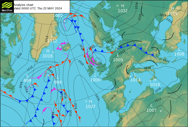
Volcanoes can be traced by their seismic output in the Met Office (UK) charts. As I am not asking you to take my word for it, you can trace them for yourself using Volcanoes Today page: https://www.volcanodiscovery.com/volcanoes/today.html
What you can see appears in the Chart that you have to visually partition for yourself as I don’t have access to anything clever especially not Artificial intelligence. I have enough trouble with just plain english without having to correct something I don’t use nor want.
Basically I have identified four sectors:
Bottom Left, thats the main thrust of our weather. That is blow Greenland to the Mid Atlantic Ridge (for with you will have to consult a submarine chart.)
Bottom right, that is the other side of the Mid Atlantic Ridge at this latitude.
Top Left, to Greenland that is Russian and Alasken volcanoes.
Now this can get sticky. My limited experience with the Top Right sector is with Anticyclonic weather, be careful with what I call those. So far I attribute them to Indonesia, Japan, New Zealand and everywhere else but you must appy your knowlege of statistics and eruption duration, becaus I am hopeless with maths especially statistics.
Something else to watch out for is Anticyclones such as the Azores High, called in the USA the Bermuba High. It is at present pushing the signals form the South and Central American eruptiond tight up against the Greenland Border. Blast it, this is not easy and I want to swear.
I can only recognise a few South and Central American volcanoes at a time and that is only because of their output. And there they are squashed betwen two anticyclones. Damnit all to hell!
I would have liked this to be easier for all of us and now I have to go shopping before tonight’s meeting. Its a bloody Dual to make things worse.
A dual is at least two large eruptions probabaly Nevado Del Ruis and Sabancay. I’ll just go and check:
Awsh..- it’s all of these and maybe more.
Popocatépetl (Central Mexico): Explosive activity continues. Volcanic Ash Advisory Center (VAAC) Washington warned about a volcanic ash plume that rose up to estimated 20000 ft (6100 m) altitude or flight level 200 .
Nevado del Ruiz (Colombia): Explosive activity continues. Volcanic Ash Advisory Center (VAAC) Washington warned about a volcanic ash plume that rose up to estimated 19000 ft (5800 m) altitude or flight level 190 .
The full report is as follows: VONA RPRT RCVD to 19000 ft (5800 m)Sangay (Ecuador): Explosive activity continues. Volcanic Ash Advisory Center (VAAC) Washington warned about a volcanic ash plume that rose up to estimated 21000 ft (6400 m) altitude or flight level 210 .
Sabancaya (Peru): Explosive activity continues. Volcanic Ash Advisory Center (VAAC) Buenos Aires warned about a volcanic ash plume that rose up to estimated 24000 ft (7300 m) altitude or flight level 240 and is moving at 10 kts in E direction.
The full report is as follows: INTERMITTENT EMISSION to 24000 ft (7300 m)
Unless you can find a better way to tell?
I hate the forma on this page getting in my way, so am I going to stay?
I will think about it. If I can find something without AI I am orft.